When making a map, it should not only consider the aesthetics, but also the performance of map. When facing a wide range of maps with large amounts of data, the poor performances of loading, rendering, querying and analyzing maps, especially on the BS and mobile terminals, which can seriously affect the user experience. In order to solve these problems, tile technology came into using.
In SuperMap GIS product system, a series of measures have been taken to improve the efficiency of online map accessing, and among them, the tile technology is the most effective way. Tile technology refers to the pre-cutting and storage of the map data / pictures in a specific way when performing map browsing, query, editing, analysis and other operations in the network map service. It can access the same data / pictures in the future without server regeneration and improve data access efficiency. At present, SuperMap supports two tile types: grid tiles and vector tiles.
Grid tiles
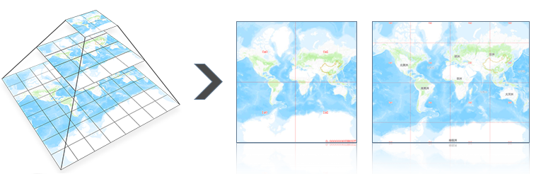
Grid tile, also called a map tile, is a map slice file that contains a series of scales and a certain map range. Map tiles are organized according to a pyramid structure, and each tile can be uniquely marked by level, row and column number. When panning and zooming the map, the browser calculates the required tiles according to the pyramid rules, obtains them from the tile server, and stitches them together.
Map tiles are a technology that improves user experience, operation efficiency, and save working time. It is a graphic display technology that commonly used in mainstream geographic information systems and making the graphic data browsing process more efficient and smooth.
Vector tiles
Grid tiles based on pictures opened the door to Internet maps, and Internet maps have quickly become popular. However, as maps become more mobile and their applications become more intensive, the shortcomings of larger grid tiles and lower generation efficiency become increasingly apparent, and they can no longer meet the needs of applications. Thus, vector tiles have emerged. The vector tiles divide and store the vector layers in the map in the form of tiles.
There are some advantages of vector tiles:
1) Vector tiles are small and highly compressible, taking up thousands of times less storage space than grid tiles. On the one hand, it reduces the network bandwidth consumption, and it makes it possible to take the map offline.
2) The generation of vector tile is efficient and saves time.
3) Vector tile data is interactive and can be edited online.
4) Vector tiles supports the modification of styles. It is no longer necessary to repeat the processes of drawing, rendering, slicing, and updating services for different styles.
Satellite Tracking + Big Data GIS Application in Real-time Ship-controlling>


