On 30 Oct, SuperMap launched the latest product - SuperMap GIS 10i at GIS Software Technology Conference 2019. SuperMap GIS 10i fully integrates AI technology, and innovates and re-builds the technology system “BitCC” of SuperMap platform software, which refers to Big Data GIS, New 3D GIS, Cloud Native GIS and Cross Platform GIS.
What is Cloud Native GIS?
With the rapid development of GIS, and the advent of challenges of massive data, intensive calculation and super-high concurrency, it is not easy for traditional GIS to make breakthroughs in capabilities and development costs. Cloud GIS integrates with cloud computing technology has emerged as needed, which is an intensive resource utilization model.
The development of Cloud GIS has gone through three stages of cloud enablement, cloud readiness, and cloud native. Also, GIS applications are constantly evolving, and the integration with cloud computing is getting closer and closer. Cloud Native GIS (Cloud Native GIS) refers to GIS-related technologies designed and optimized for the cloud environment. Base on the micro-service structure and taking containers as deployment carriers, it can orchestrate automatically and make better use of cloud platforms capabilities for more efficient and flexible GIS systems.
Among these, micro-service divides the complex monolithic application into several service modules, and each module focuses on a single business and provides service for outside. Container, as one of the virtualization technologies, it can encapsulate applications into images and provide isolated and independent operating environments for micro-service. Also, the automated orchestration technology provides distributed, automated deployment and management solutions for micro-service.
Cloud native GIS solves the problems of traditional GIS, such as, slow in upgrading, complex architecture, inability to quickly iterate, and failure to quickly locate faults.
What can Cloud Native GIS do?
SuperMap Cloud Native GIS assists the digital transformation, which can be used in geographic information cloud platform construction, smart city construction, resource management construction to solve the challenges in big data era.
The following contents shows the advantages of SuperMap Cloud Native GIS:
Fast delivery: Through the DevOps process, it can quickly build GIS images, and use the feature of one container to run without discrimination at multiple locations, and users can quickly migrate from the research and development environment to the production environment without any difference.
Convenient upgrade and expansion of project applications:Cloud Native GIS supports convenient integration of industry applications. Also, there is no need to upgrade the entire system like traditional applications, but only transform local micro-services when requirements changes.
Ensure the stability and availability of system: Failure of traditional applications will result in unavailability of functions, and Cloud Native GIS has a container inspection mechanism. Once abnormal containers are found, they will be automatically destroyed and rebuilt to ensure uninterrupted supply of services. The stateless feature of Cloud Native GIS also ensures that the original features are preserved after reconstruction without data loss.
The efficient cluster construction: The cluster mechanism adopted by traditional GIS applications to solve the problem of system stability and availability for users is cumbersome to build and takes up a lot of resources. While Cloud Native GIS does not need to manually build a cluster. After the deployment, it can implement fine-grained automatic clustering, fault repair, rolling upgrade and elastic scaling.
The Could Native GIS Technology Architecture
SuperMap has formed a mature Cloud Native GIS technology architecture. SuperMap Cloud Native GIS can shield the differences in multi-cloud environments and can be deployed in any cloud environment such as Alibaba Cloud, Huawei Cloud, OpenStack, etc. to reduce management and migration costs. It can be connected to public computing and storage environments in the public cloud, and provide built-in distributed computing and storage to realize one-click deployment of GIS big data. Also it can split GIS capabilities into finer granularity through micro-service restructuring to make GIS services more stable. Through the automatic orchestration of SuperMap iManager + Kubernetes, dynamic resource scheduling and integrated operations maintenance management can be conducted and the fine-grained elastic scaling of GIS services can be achieved.
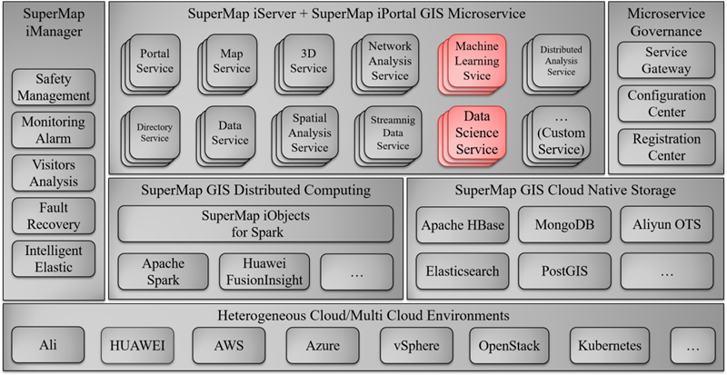
SuperMap Cloud Native GIS technology system has four aspects:
GIS data Cloud Native storage and distributed computing make GIS more efficient. It provides the storage capacity of spatial data, supports distributed storage of multiple types of spatial data, including vector grid data, stream data, tile data, and 3D data, and improves the efficiency of massive spatial data operations, including the construction of regional grids, point aggregation analysis, density analysis, single object spatial query, area summary analysis, vector cropping, overlay analysis, buffer analysis, etc. which can achieve the improvement of performance. Also, it supports for a variety of public cloud storage services, cloud databases to take advantage of cloud platforms. It can effectively solve the problems of rapid growth of massive data and high storage and processing pressure.
GIS micro-service architecture and service governance make GIS more stable. It supports GIS functions to be split into micro-services, which can achieve comprehensive micro-services of map, 3D, big data, and AI functions. GIS micro-service scheduling is based on Spring Cloud for service governance, including service gateway, GIS business layer, configuration center, registration center and other parts. The split micro-service module logic is simpler and easier to maintain and update. At the same time, due to loose coupling, a single failure will not propagate, which improves system stability.
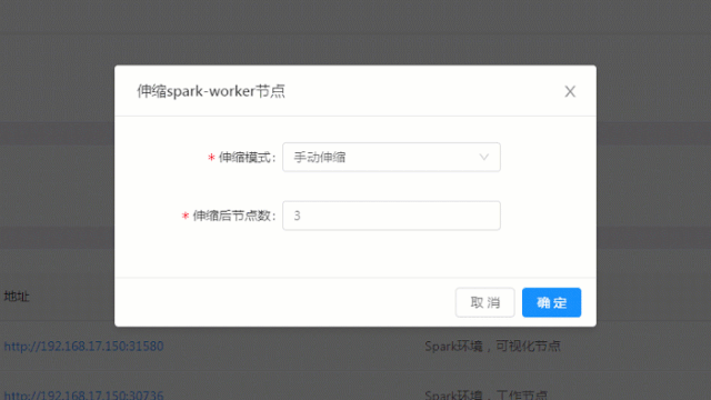
Container-based multi-node deployment and elastic scaling make GIS more flexible. When compared with virtual machines, it has faster deployment speeds and lower performance losses. And when combining it with Kubernetes' general-purpose orchestration, containers can quickly deploy multi-node cloud native GIS environments. SuperMap Cloud Native GIS supports GPU computing power containerization and comprehensively improves AI GIS analysis performance; through container technology, it supports undifferentiated operation in public cloud, private cloud, and hybrid cloud environments, which can reduce migration costs; through the elastic scaling mechanism, GIS micro-service nodes can automatically scale with the pressure increases / decreases, which can increase nodes during high concurrency, processing capacity, and reduce nodes when pressure decreases, and achieves resource intensiveness.
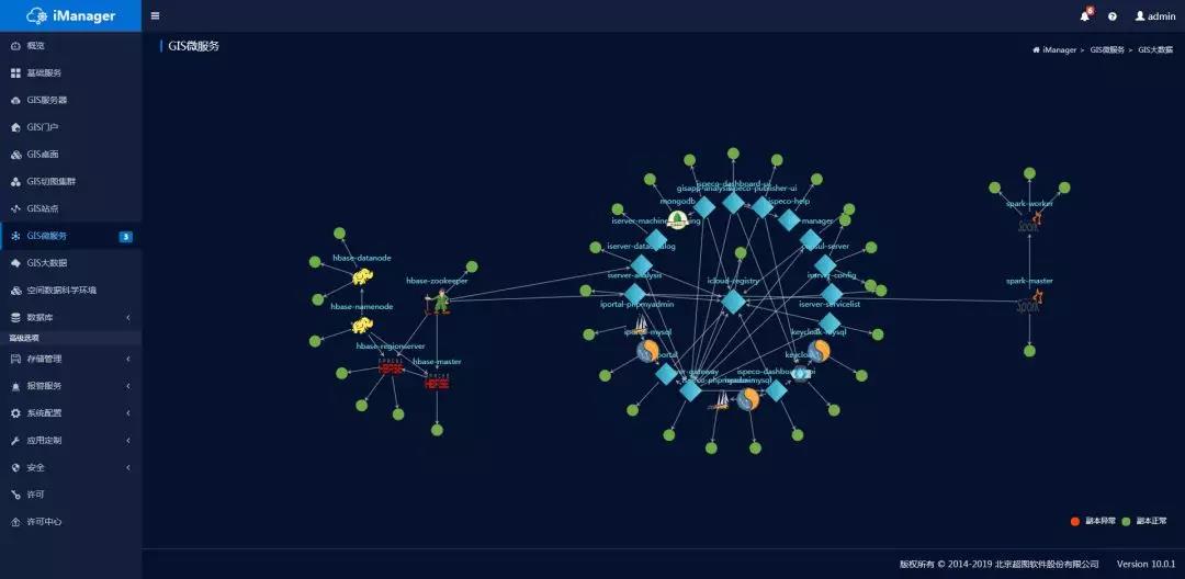
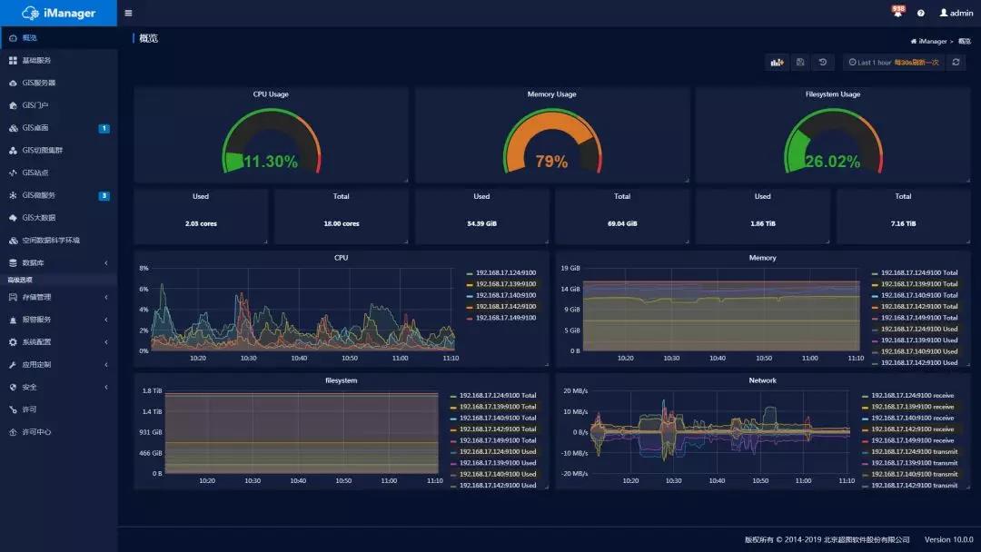
Integrated intelligent operation and maintenance management, check real-time system status. By applying the SuperMap iManager integration GIS operation and maintenance management center, GIS application service management, infrastructure management, and big data management of all microservice resources can be achieved. It supports log query, access analysis, use real-time topology diagram to view service status, and understand the association between services; supports monitoring service CPU, memory, disk and network system file usage; supports seamless upgrade, realizes local upgrade / rollback without interrupting GIS service. Users can create 8 GIS application environments and 7 GIS database environments with one-click. In terms of scalability, it supports the integration of third-party industry applications to achieve the purpose of unified supervision of GIS and other applications.
Cloud Native GIS meets the changing GIS needs, and it is the innovation of GIS development and deployment methods. It is suitable for any cloud GIS platforms with the stable operation mechanism and flexible scalability to ensure the service supply. SuperMap Cloud Native GIS integrates advanced technologies and solutions in continuous practice, which leads it to be the new-generation cloud platform.
Satellite Tracking + Big Data GIS Application in Real-time Ship-controlling>


