To view the first part of the introduction, please click here.
BIM data performance optimization
Instantiation technology
Instantiation technology is suitable for situations where there are many repeated models. It can draw the same geometric model only once, reducing the pressure on hardware devices such as graphics cards.
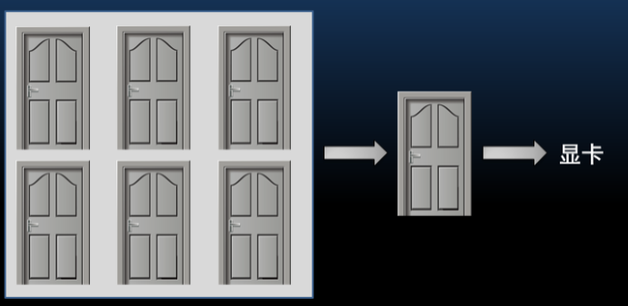
Instantiation diagram
As shown in the picture above, there are a large number of identical "door" objects in a house. Using instanced rendering technology, you can save and draw only one object, which reduces the pressure on the graphics card, memory, etc., and improves the performance of the three-dimensional scene.
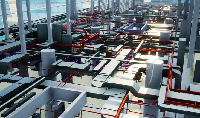
In actual projects, as shown in the figure below, through instantiation technology, the 18G BIM cache of 74,000 objects was reduced to 22M, retaining instantiation information and improving loading performance.
LoD
LOD technology is the abbreviation of Levels of Detail, which means multiple levels of detail. LoD technology refers to determining the resource allocation of object rendering based on the location and importance of the nodes of the object model in the display environment, reducing the number of faces and details of non-important objects, thereby obtaining highly efficient rendering operations.
When the 3D scene is zoomed in and viewed, the model displays every detail. When browsing the entire scene, the model only needs to be displayed in a rougher way. This optimizes resource usage to the greatest extent and improves the performance of the entire 3D scene.
Lightweight structure
It refers to a kind of structure where some skeletons of the model are deleted or simplified. The level of sophistication of BIM data in different fields is also different. For GIS applications, depending on the actual needs of the project, importing BIM data into the 3D GIS platform requires lightweight operations to varying degrees.
SuperMap products provide a variety of BIM lightweight and triangulation operations, including: shell extraction (shell and interior separation), triangulation simplification, sub-object simplification (deletion), deletion of duplicate vertices, calculation (deletion) of normal, and models split, model merge and many other practical functions.
BIM and multi-source data integration
The development of 3D technologies such as oblique photography and laser point clouds has lowered the threshold and cost of data acquisition, and increased the frequency of data updates. The development of BIM technology has provided more detailed 3D models for 3D GIS, allowing for more refined management of GIS. Changes in the way of obtaining 3D data have made it possible to obtain a large amount of 3D data. As large-scale 3d data continues to accumulate, the fusion and matching of multi-source data becomes particularly important.
With the rapid development of data collection technology, the generation of spatial multi-source data has brought new challenges to the integration and application of GIS data. Therefore, achieving efficient integration of massive spatial data from different sources and different resolutions has practical significance for reducing the construction cost of GIS application systems and improving the utilization efficiency of spatial data.
The SuperMap 3D Designer three-dimensional geographical design engine further strengthens the construction, computing and processing capabilities of oblique photography models, TIN terrain, BIM and other data, thereby breaking through the limitations of traditional GIS software in multi-source three-dimensional spatial data fusion and analysis and calculation. This can help users build accurate large-scale 3D scenes, which solves various difficult problems in the underlying data processing of GIS applications and effectively shortens the project construction cycle.
To integrate and match the multi-source data in a 3D scene, the first step should be coordinate conversion and data registration to unify BIM, oblique photography models, point clouds, etc. with other GIS data into one coordinate system. SuperMap provides coordinate projection conversion of various 3D data, including: models, raster, images, point clouds, oblique photography models, etc.
Integration of BIM data and water surface data
BIM+game engine
SuperMap 3D GIS game engine development platform ( SuperMap Scene SDKs for game engines) uses the SuperMap Pro plug-in to load and display GIS data on the game engine, and provides integrated functions from data production to data release through the tool chain.
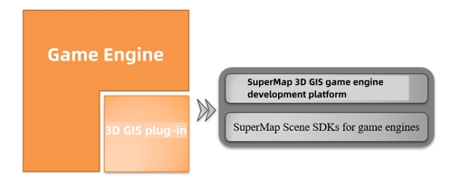
The relationship between SuperMap GIS and game engines
The SuperMap Pro plug-in is a plug-in tool in the Unity editor based on SuperMap Scene SDKs for game engines. It has a friendly interface and is easy to use. It supports local/online browsing, layer control, query, spatial analysis and other functions regarding a variety of massive GIS spatial data such as images, terrain, oblique photography models, artificial models (AI), BIM, etc.
GIS data visualization
It adds an S3M layer to the game engine to support the loading and display of multi-source, large-scale online/offline real-life 3D data; and adds a 3D earth to support local/ online terrain and image data.
Interaction
Based on the visualization of large-scale, multi-source heterogeneous 3D data, the platform provides capabilities such as attribute query, BOX cropping, and flight positioning.
GIS empowers BIM to CIM
The SuperMap CIM platform relies on a 2D and 3D integrated GIS platform and organically integrates SuperMap BIM+GIS capabilities to achieve unified aggregation, processing, and management of BIM data. It provides comprehensive support capabilities from data to functions to services for multi-dimensional urban life cycle management, thus comprehensively empowering a series of CIM+ applications such as urban planning, construction, management, operations, and services.
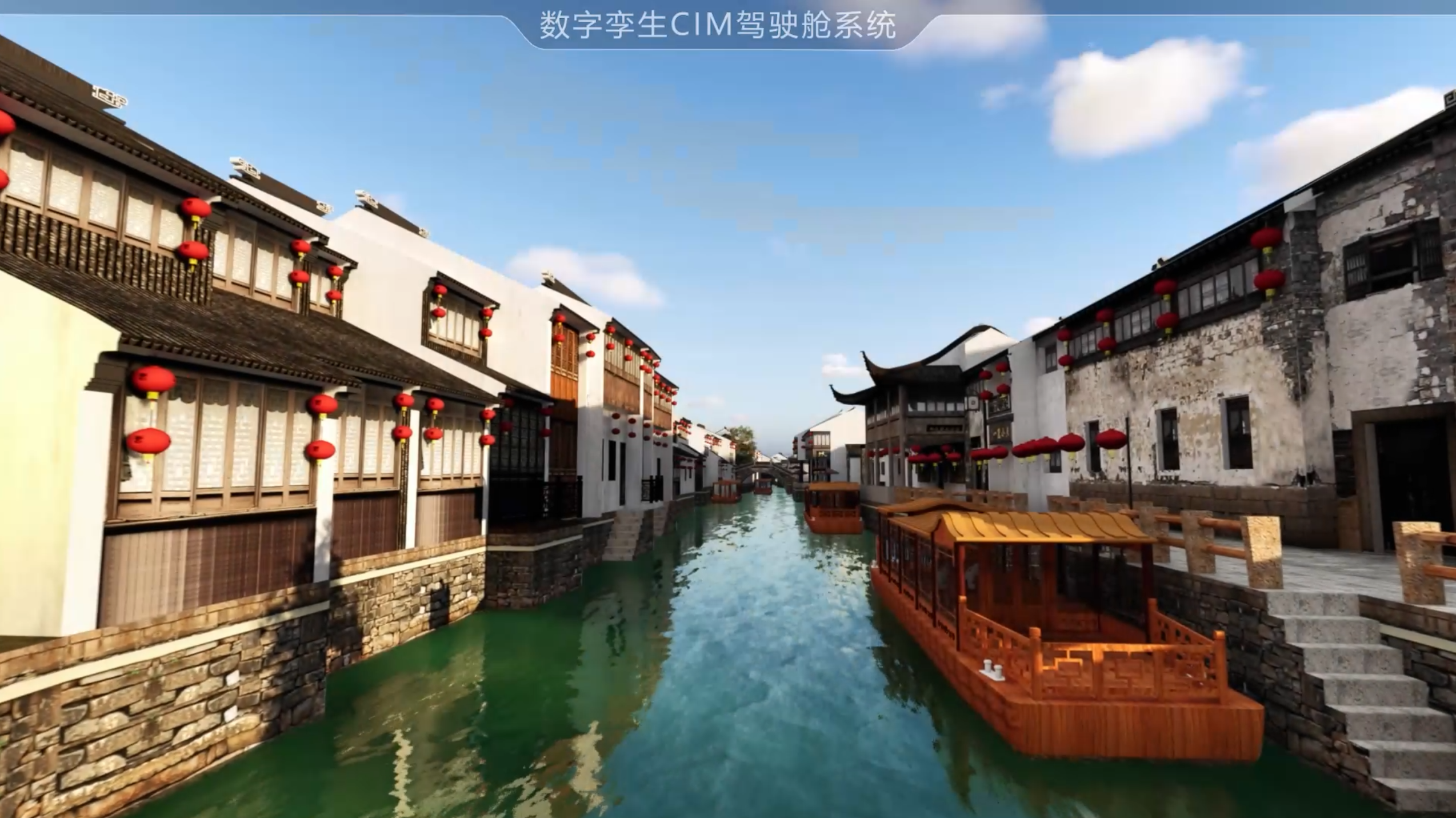
BIM data visualization based on game engine
End.


