At present, with the continuous upgrading of various satellites and sensors, the demand for data production volume and production accuracy is also increasing. How to efficiently interpret, analyze and process images has become the focus of attention in various industries.
SuperMap ImageX Pro 2024 further innovates algorithms and deeply integrates AI technology to add capabilities such as vegetation enhancement, image cloud removal, intelligent restoration of water elevation, and image quality inspection to improve the quality and efficiency of image data production.
Strengthening functions for easier image production
Access to multiple image sources
To meet the access needs of more image sources, SuperMap ImageX Pro 2024 adds access to remote sensing images of BJ3N3, JL-GP, K3, and SuperView NEO-1 optical satellite sensor types; it supports using *.pix image files as reference images, expands the data source of reference images, eliminate the need to convert image formats, thus simplifying the import process.
Automatically image filtering
In the face of multi-source remote sensing images, due to differences in image acquisition time, resolution, cloud content, etc., it is necessary to screen the images to retain image data with similar time, high resolution, and less cloud content, thereby improving the quality of image production. SuperMap ImageX Pro 2024 provides an automatic screening tool that can quickly filter qualified images based on the specified time range, resolution range, cloud content, and whether there are duplicate names, without the need for manual selection. This can significantly improve work efficiency when processing a large number of images.
More built-in processing automation
To meet the diverse production business needs, SuperMap ImageX Pro 2024 provides three major automatic processes: DOM production from panchromatic and multispectral images, DOM production from orthophotos, and DSM/DEM data production. These processes implement the T+1 mode of acquiring data on the same day and applying it the next day, greatly improving production efficiency and application speed. At the same time, the reusable nature of automatic processes is particularly suitable for regular data updates, effectively ensuring the consistency and stability of the processing results, and bringing users a more convenient and efficient remote sensing image processing experience.
Improved processing capabilities for better image production
Clearer image fusion
SuperMap ImageX Pro 2024 is based on image fusion algorithms such as Gram-Schmit and Pansharp , and supports custom sharpening coefficients to make the fusion results of panchromatic and multispectral images clearer. It also supports the direct use of local files as data sources, and image fusion results can be obtained without relying on automated processing procedures.
Better true color output
True color images can truly reflect the color characteristics of actual objects. However, when obtaining the original image, it may be affected by the weather, angle and other shooting conditions, and the display effect is not ideal. Therefore, in the true color output, image degradation and band order adjustment are supported to improve the display effect of image detail; by enhancing vegetation, the display effect of vegetation areas in the image is improved; linear stretching display is provided, and automatic calculation of truncation percentage is supported. The threshold of highlight white spots is adjusted according to the image brightness, the overall brightness effect of the image is optimized, and the contrast of the image is supported.
More natural image color
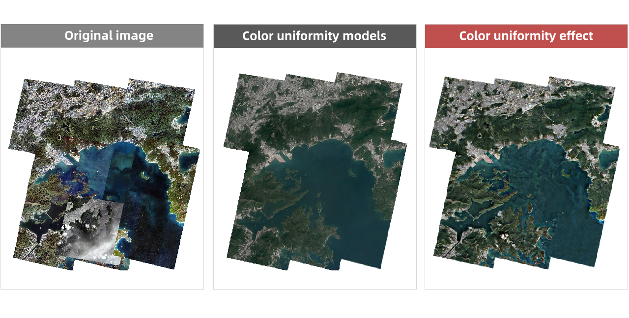
Affected by weather conditions, human factors, and sensor factors, the original images obtained have problems such as inconsistent color and brightness, which leads to errors or color aberrations during image splicing, affecting the visual effect of the entire image.
Image color equalization can correct the uneven distribution of image brightness, contrast, hue, and saturation based on specified color equalization processing methods to ensure that the display effect at each position of the image is basically consistent. In this version, the image color equalization algorithm has been upgraded, providing geographical color equalization templates, block color equalization and other methods, which not only ensures the uniformity of color of land objects, but also significantly improves the color uniformity of water body areas.

Image color uniformity
More thorough removal of fog and haze
Affected by weather conditions such as haze, remote sensing satellites may experience color distortion, reduced contrast, and other problems. Effectively removing haze from remote sensing images can enhance contrast and restore image detail information to a certain extent. SuperMap ImageX Pro 2024 uses an atmospheric scattering model to remove haze from images and improve image clarity overall.