SuperMap iPortal is a GIS portal platform software that integrates GIS resource integration, search, sharing and management. It is equipped with the capabilities of zero-code rapid site building, multi-source data access, multi-source heterogeneous service registration, and multi-source service security access control. SuperMap iPortal provides a variety of Web applications, supporting thematic map production, spatial element editing, distributed spatial analysis, 3D visualization, 3D modeling, automation of spatial data processing and analysis, and industry large-screen creation and display.
In SuperMap GIS 2024, SuperMap iPortal, as a GIS portal platform, has upgraded and optimized the management capabilities of resources and users. The built-in multiple WebApps also provide more professional mapping capabilities, more efficient collaboration capabilities and easier-to-use modeling processes, thus bringing a more convenient and efficient experience to the management and application of GIS resources.
Resource access management upgrades and service sharing security enhancements
Multi-source data access
In terms of resource integration, the upload of file data in FileGDB format has been added to the original Excel, CSV, SuperMap workspace, Shapefile, SMTiles, TPK, GeoJSON and other types of data. At the same time, the support for registered PostGIS, PostgreSQL, and MySQL database storage has been added to achieve the integration, management and application of multi-source heterogeneous data in the portal. The data of the registered database will be automatically published as a service, which can be used in WebApps for thematic map production, insight analysis, or direct use of data for modeling operations.
Improvement in resource review mechanism
In the process of using SuperMap iPortal, in order to maintain the compliance of site content, the new version has added data, insights, large screens, and scene audit mechanisms based on the original map, service, and project resource audits, aiming to prevent the unauthorized dissemination of sensitive information.
When the administrator turns on resource auditing, resources added and edited by users need to be approved by the administrator before they can be publicly displayed in the portal, ensuring information compliance. In addition, the new version has also optimized the resource audit process. Users can manually submit audits based on actual conditions, avoiding the problem of automatically submitting resources before they are edited, reducing the burden of repeated audits on administrators, and improving resource management efficiency.
More granular service sharing
To ensure data safety, the new version supports setting the spatial range accessible to shared objects when sharing services. In previous versions, SuperMap iServer REST map service, REST vector tile service, REST data service, OGC Spatial scope permission control are performed for multiple service types such as WMS services, OGC WMTS services, and image services.
In the new version, the mvt tile request (xyz format) of the newly added data service and map service supports spatial scope permission control. At the same time, the query performance of the data service after setting the spatial scope access control is greatly optimized, bringing users a safer and smoother service access experience.
User management capabilities are optimized for simple and easy-to-use resource migration
Added support for WeChat account login
In terms of login configuration, SuperMap iPortal not only supports the integration of existing account systems based on CAS, LDAP, and Keycloak, but also supports the use of third-party account login based on the OAuth2.0 protocol, and can configure QQ and Sina Weibo account login. On this basis, the new version further adds support for WeChat account login, which allows quick login without filling in username and password.
Supporting migration of assets when deleting users
A user's resources are associated with other resources. In previous versions, the user's resources will be deleted the same when it is deleted, which will not only lead to the loss of important resources, but may also affect the use of other resources.
In view of this, when deleting a user, the administrator can choose to migrate the user's assets (owned resources, groups, keys) to other users before deleting the user. In addition, in order to facilitate administrators to evaluate the importance of the user's assets and make decisions on whether to retain the assets, the function of viewing asset details is provided to ensure that important resources can remain in the portal and continue to be used.
Enhanced web mapping capabilities make it easy to create professional maps
More powerful symbolic mapping capabilities
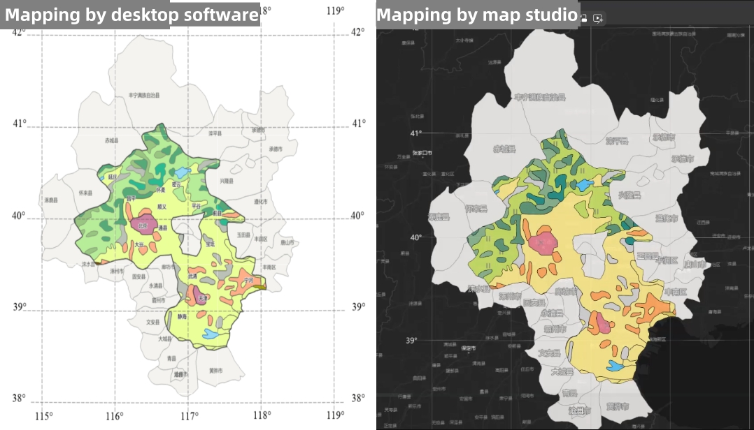
In the Map Studio WebApp, users can create beautiful Web maps through simple and flexible map style configuration. In the new version, Map Studio has launched a Web symbol library that can be used for symbolic mapping, with built-in 4000+ Web symbols, line types and fills. The symbol style is close to the professional symbol effect of desktop software; the symbol types are rich and can meet the mapping needs of various industries such as transportation, land, and integrated pipe networks. Based on the above capabilities, users can achieve the mapping effect of desktop software through online Web mapping, while effectively avoiding the difficulty in modifying symbols after the map service is released.

Comparison of cartographic results between desktop software and map studio
More layer styles provided
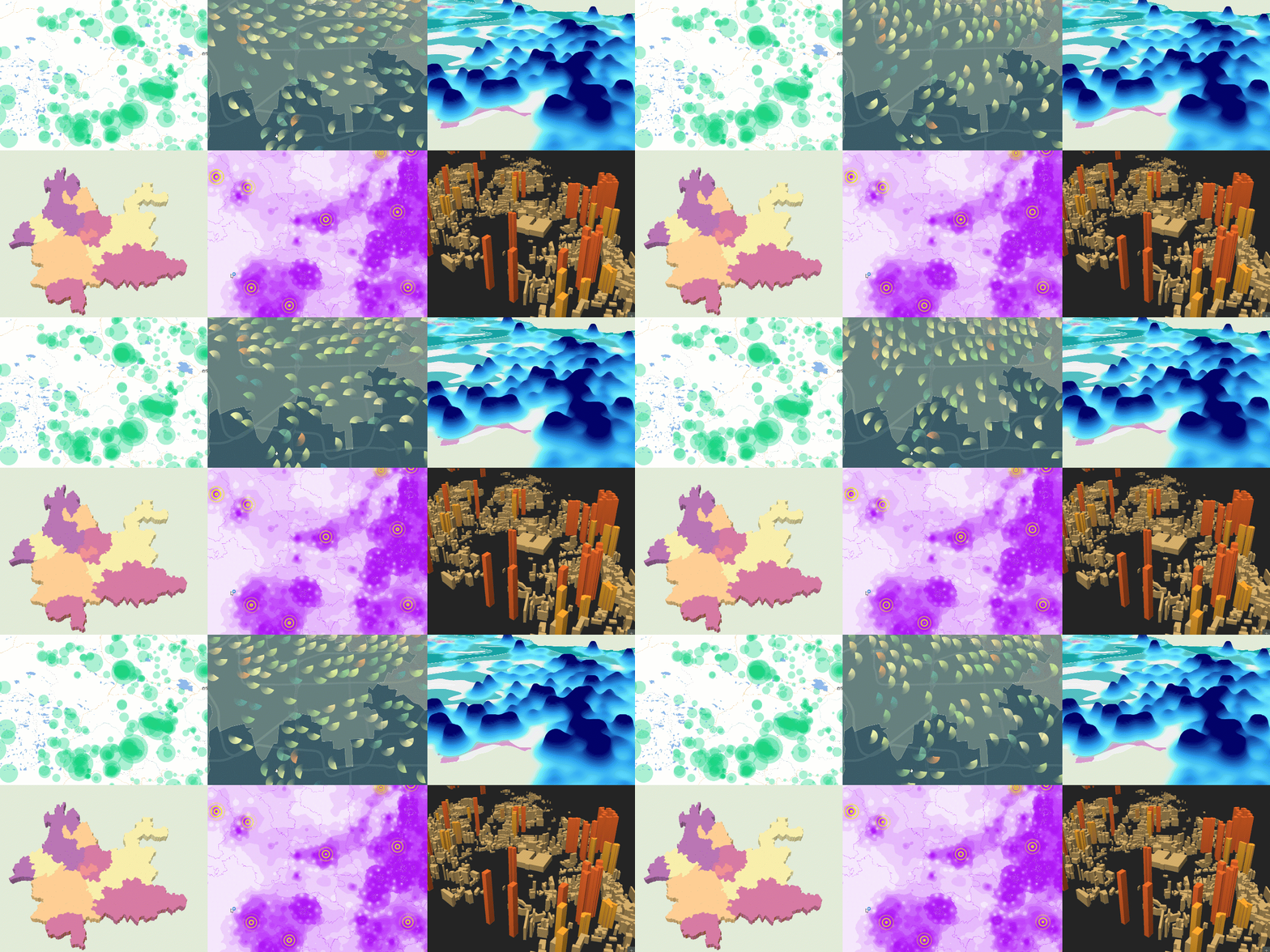
In order to further enhance the visualization effect of the map, Map Studio has added more than 10 styles types including point, line, and surface layer, including grid maps, honeycomb maps, animations, OD maps, line effects, statistical charts, etc. Users can choose a more suitable data expression form according to their needs.
The setting method of layer style is also very simple. Users only need to select the style type and adjust the display parameters to present static/dynamic, 2D/3D and other beautiful visual effects in the map, and easily generate professional and high-quality map works.

Rich 2D and 3D visualization effects
Quick drawing template added
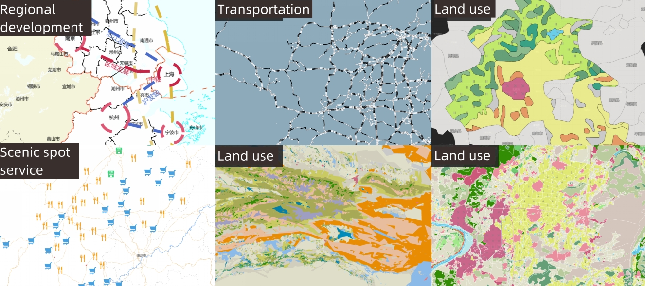
Based on the Web symbol library and rich layer styles, Map Studio also provides a variety of mapping templates such as point, line, surface layers, heat maps, aggregation maps, symbol composite maps, etc., which simplifies the mapping process and promotes the rapid implementation of standardized mapping. At the same time, it avoids the problem of inconsistent mapping effects due to differences in personal usage, and improves the professionalism of the map.

New and diverse web graphics templates
To be continued...