03 Data Visualization
In classic GIS products, in order to complete data visualization tasks, users need to select the corresponding products and applications, create projects or new workspaces, and implement different visualization operations by clicking controls and performing form operations in the toolbar of the project workbench.
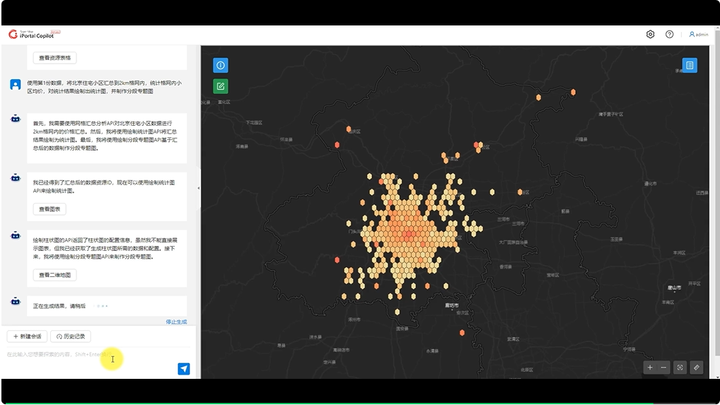
In SuperMap Copilot (preview version), users only need to give specific analysis instructions, such as " display with a bar chart " and " draw a segmented thematic map ", to easily visualize the data. SuperMap Copilot (preview version) also supports multiple demands in one sentence, such as " first conduct a grid summary analysis of Beijing's residential areas, then do a statistical analysis of the average price of the communities in the grid, then draw a statistical chart, and finally make a segmented thematic map ", and the geospatial artificial intelligent agent will decompose, plan and execute the tasks until all demands are completed. Under the intelligent interaction mode of SuperMap Copilot (preview version), the previously cumbersome multi-step and even multi-application operations can now be easily completed in one sentence.
In addition, the right interface of SuperMap Copilot (preview version) retains the classic control interaction, and users can still change the visualization effects and perform other control analysis operations by clicking.
Currently, SuperMap Copilot (preview version) supports visualization of statistical charts such as pie charts, column charts, radar charts, bar charts, and line charts, as well as two-dimensional map visualization of basic maps, single value thematic maps, segmented thematic maps, and heat maps.

SuperMap Copilot (preview version) statistical analysis, two-dimensional data analysis and visualization
04 Portal Management
If you are a portal administrator, you can also use SuperMap Copilot (preview version) to conveniently manage portal resources and users, and visualize portal resources and user details.
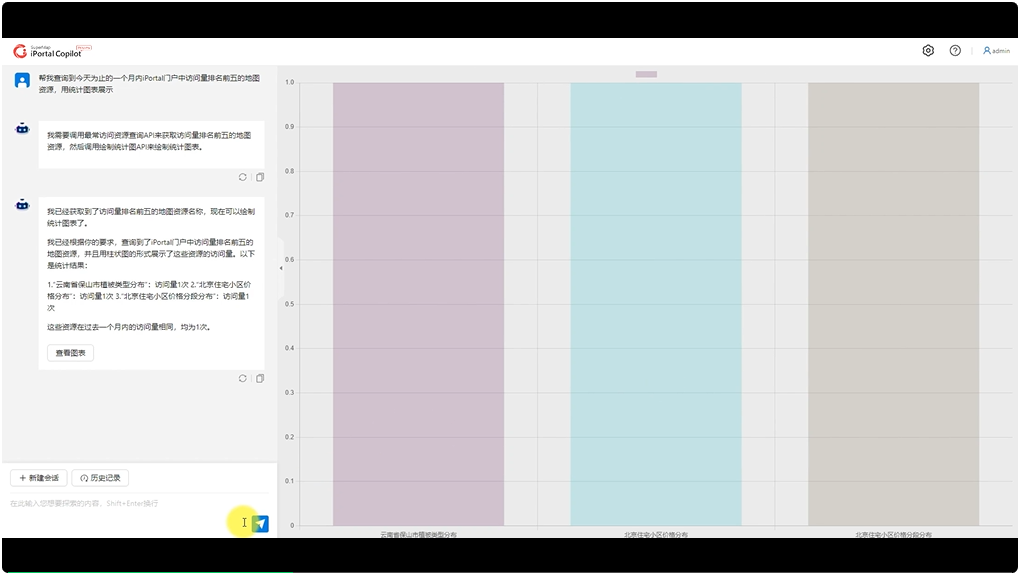
For example, when you want to know the access status of a certain type of resource, if you use the traditional interactive method, you need to click "Portal Statistics -> Access Statistics -> Map -> Select Date (or select the Last 30 Days tab)" on the management page. With SuperMap Copilot (preview version), users can say: " Help me query the top five map resources in iPortal in the past month , and display them in statistical charts", then you can get the final chart, which greatly simplifies the interactive steps.
Similarly, user management can also be easily done through text commands. For example, tell SuperMap Copilot (preview version) " I want to view the user login status within one year and present it in a line graph ", and Copilot can complete the query and draw the statistical graph in sequence. In addition, you can also ask SuperMap Copilot (preview version) some questions based on the query results, such as "Tell me which users have logged into the portal the least times ". It will also think and answer the questions autonomously.
SuperMap Copilot (preview version) currently supports the following resource management capabilities: querying the total number of portal resources, querying the number of resources of each type, and querying the number of resource visits within a certain period of time; the supported user management capabilities include: querying the total number of portal users, querying the number of users of each type, querying user information created within a certain period of time, deleting users, and migrating user resources.

SuperMap Copilot (Preview Version) Portal Management
05 Third- party capability expansion
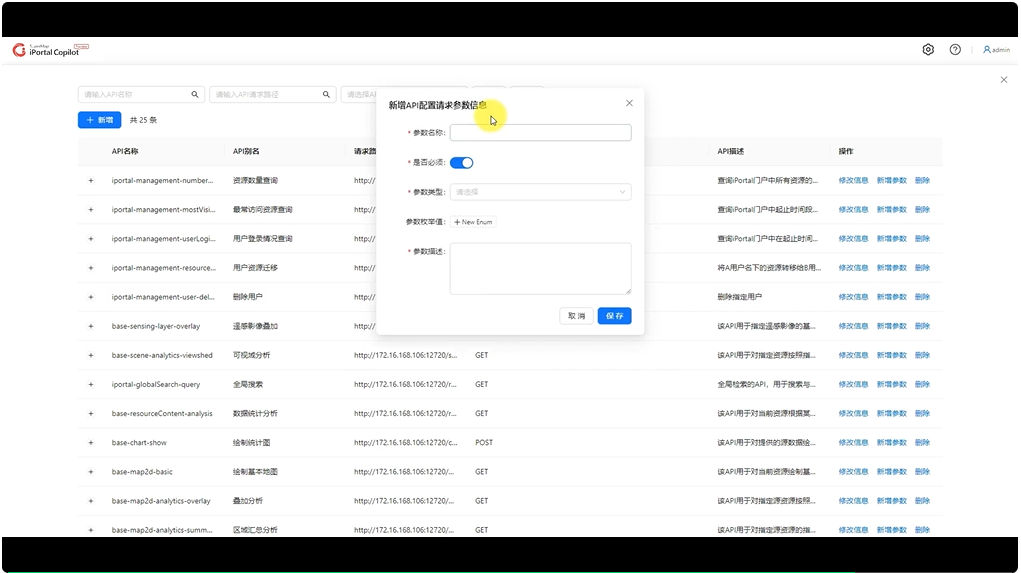
In addition to the capabilities supported above, SuperMap Copilot (preview version) also supports third-party capability expansion. Users can easily integrate the business interfaces of industry scenarios into Copilot, giving Copilot richer capabilities. When the user enters a request in the dialog box, Copilot will determine whether a new API tool needs to be called to complete the task.

SuperMap Copilot (Preview Version) third-party capability extension
SuperMap Copilot, with GI Agent as the core, will expand and support richer GIS capabilities, gradually achieve deep integration with SuperMap Cloud GIS products, and bring a more powerful GIS intelligent interactive experience.
Based on the capabilities of geospatial intelligence and flexible scalability with third parties, SuperMap Copilot will continue to empower multiple fields such as intelligent real estate registration, intelligent spatial planning, intelligent water conservancy system, intelligent meteorological monitoring, and intelligent safety and emergency response to accurately meet the needs of industry business scenarios, and jointly promote the intelligent upgrade of various industries.
The end.