Xiong'an New Area is a national new area established in 2017 in China. Empowered by advanced technologies in modern times, it aims to be built into an innovative digital city following the high-quality development philosophy. With BIM+GIS+IoT technology, a BIM platform is built to realize intelligent management of the whole area.
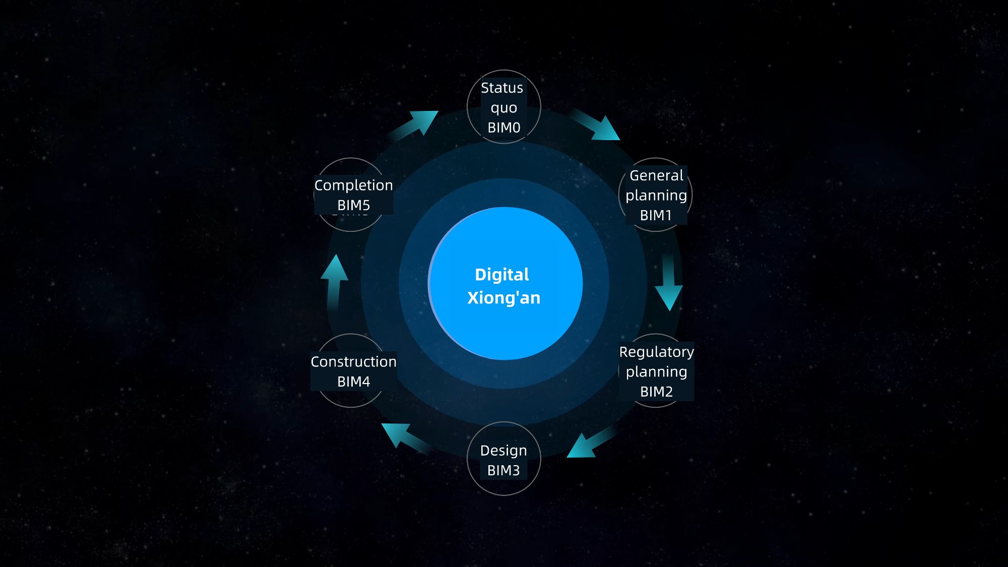
Six major links cyclically iterated to realize full-process digital control of Xiong’an construction
Construction content
The construction content of the BIM management platform (Phase I) includes: full-process management of data assets, business function component-level support, implementation of BIM0-BIM5 all-factor cross-industry system review system, safety assurance system and standards, and completion of records of the entire process of new area development, control and management.
The subsystems include cockpit subsystem, urban spatial information thematic analysis subsystem, workbench subsystem, current spatial information subsystem, overall planning information subsystem, detailed planning information subsystem, design plan information subsystem, engineering construction information subsystem, and project completion information subsystem.
Technical route
The construction of the BIM management platform (Phase I) revolves around one "core task", namely: simultaneous planning and construction of digital cities and real cities. The BIM management platform records the digital Xiong’an self-growth by iterating in six major links: the current status of urban construction (BIM0), general planning (BIM1), regulatory plan (BIM2), design (BIM3), construction (BIM4), and completion (BIM5).
Overall platform construction plan
Technology innovation to create the foundation for the construction of "Digital Xiong'an"
The BIM management platform (Phase I) integrates multi-source spatial data to achieve data exchange and business collaboration within the planning and construction bureau and between relevant commissions and bureaus to improve administrative management efficiency and service levels, and provide digital, visualized and scientific decision-making basis for planning and construction issues, laying the foundation for the construction of "Digital Xiongan". As the only GIS platform manufacturer participating in the construction of the BIM management platform for the planning and construction of Xiong’an New Area, SuperMap made use of its own advantages and solved a number of key technical issues to ensure efficient and stable operation of the platform.
A digital base that provides massive multi- source data based on WebGL technology
The platform is based on WebGL technology and has technical features such as full data, full function support, full time and space experience, and is lightweight and extensible: it supports terrain, images, dynamic layers, field layers and other data; it expands the analytical capabilities of WebGL and fully supports functions such as spatial operations, spatial queries, spatial analysis, and rule modeling. It can handle high-fidelity rendering of complex three-dimensional urban data and facilitate the construction of Web applications.
Unified data standards to provide BIM services throughout the whole life cycle
The XDB open data format ensures the exchange of multi-professional indicator data such as planning, architecture, municipal administration, geology, etc., and the application and collection of data in different construction stages. XDB remains open in content and format, and can meet the diversity and unification requirements of BIM application software. S3M, as an open and extensible 3D geospatial data format, provides data format specifications for the transmission, exchange and sharing of spatial 3D model data between different terminals, which is of milestone significance in promoting the sharing and in-depth application of 3D geospatial data.
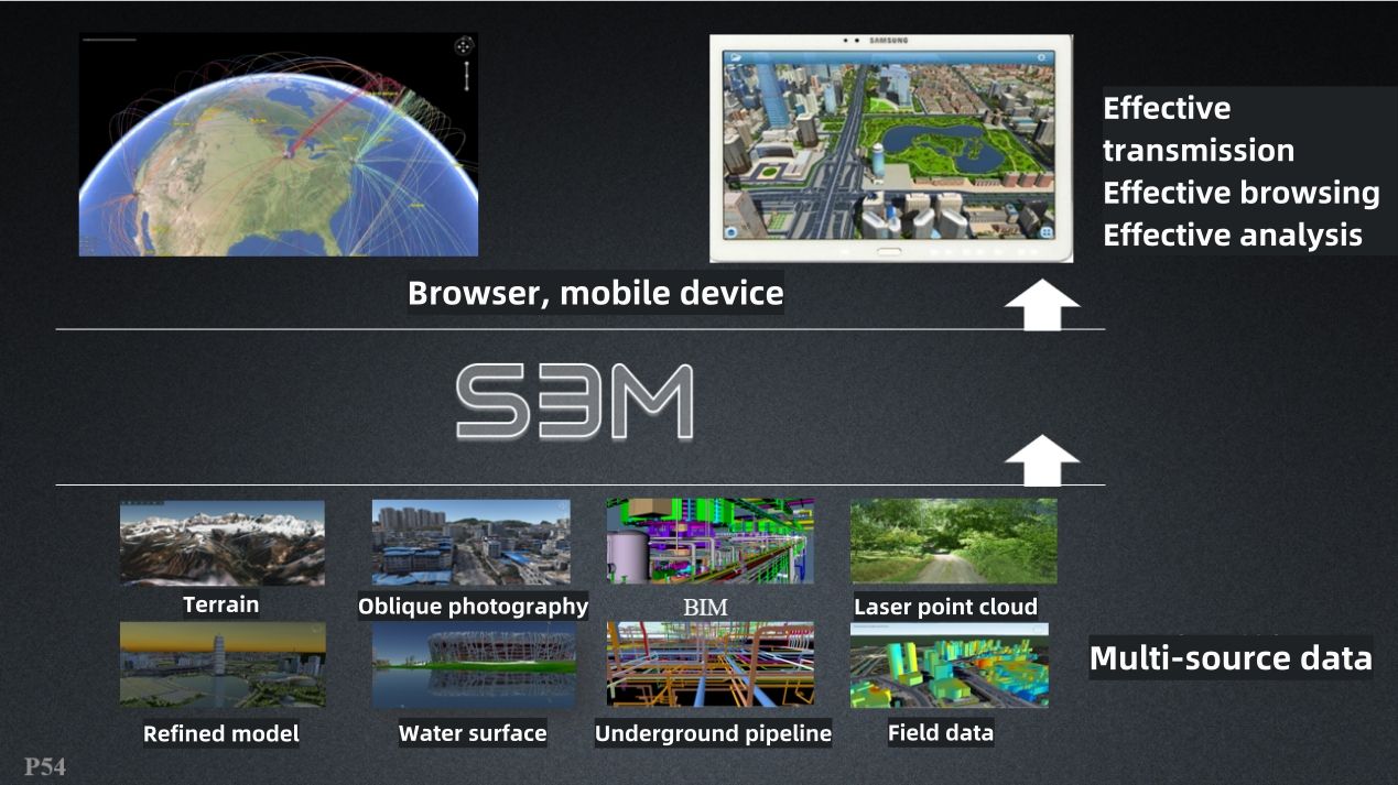
Spatial 3D model data format (S3M)
Three-dimensional spatial analysis and computing capabilities improve digital approval efficiency
The prerequisite for realizing urban computing is to have rich and diverse spatial data models to realize the full spatial expression of the entire urban space. The spatial data model is the geographical information system's knowledge and understanding of real-world urban geospatial entities, phenomena and their mutual relationships. It is the basis for the abstraction and expression of real-world urban objects in computers.
Improve efficiency and create a basic technology platform for efficient operation and intelligent innovation
Economic benefits
1. Reduce capital investment in duplicate system construction
The platform created an efficient and streamlined government approval model for information featuring sharing and business linkage through multi-source, multi-scale, and multi-time and multi-space information fusion and application, which will greatly reduce the duplication of approval and processing work in various departments and reduce the development and investment costs of individual management and approval platforms for various industries in urban management, and then achieve multi-industry and cross-field business collaboration in planning, construction, municipal administration, geology, transportation, land, gardening, etc., thereby achieving the purpose of reducing capital investment and indirectly generating economic benefits.
2. Save administrative costs of repeated collection of information
Due to the lack of a sharing and exchange mechanism for existing business information, and in order to meet their own business management needs, various government departments must allocate a large amount of manpower, financial and material resources to collect relevant basic and business information every year. After the platform is completed, on the one hand, it can eliminate a lot of unnecessary duplication of work; on the other hand, it can open up the business information held by various departments, which can greatly reduce administrative costs.
3. Promote effective allocation of resources
When the BIM management platform (Phase I) is completed, it will realize effective sharing of information resources, enhance the business capabilities of collaborative work, promote the effective allocation of resources, and greatly improve work efficiency.
Social benefits
The platform provides a basic technology platform for the efficient operation and intelligent innovation of various management departments in Xiong’an New Area, especially the planning and construction management department. The platform will seize the commanding heights of digital city planning and construction management concepts, standards and rules, and realize the "data-based, informatized and process-based" urban planning and construction management work.
1. Improve the department's ability to perform its functions and the government's credibility
The platform makes full use of the national unified e-government network, data exchange platform and modern information technology means, which can give full play to the monitoring and screening capabilities, business operation guidance and information transparency of the information system to realize full-process approval management throughout the status quo monitoring, general planning, control planning, design, construction, and completion, thereby innovating administrative management methods, improving government credibility and execution, and promoting government performance management.
2. Promote the modernization of the governance system and governance capabilities of Xiong'an New Area
The platform fully embodies the advanced concept of "people-oriented" and integrates management into services. The starting point and foothold of urban management is to serve the citizens, respect the wishes of the citizens, form a positive interaction pattern between citizens and the government, and jointly manage the city.
3. Establish a "national model" and build a "world model"
It is the first to innovate and build a new integrated system of "planning, construction and management" for the development of future digital cities, formulate a new standard system for planning, construction, management, use and maintenance of digital twin cities in Xiong'an New Area. With management innovation as the starting point to increase supervision and service efforts, it aims to become a national model for the symbiosis of digital and real spaces.


