The 14th National Winter Games of the People's Republic of China (hereinafter referred to as the "14th Winter Games") has been held in the Inner Mongolia Autonomous Region from February 17 to 27, 2024.
It is the one with the highest standard, the largest scale, and the most comprehensive event in the history of the Winter Games. The organizing committee has very strict meteorological requirements, which places high demands on meteorological support work. During the 14th Winter Games, organizers not only need to observe meteorological data in real-time and every minute, but also need to grasp the weather changes in and around the event venue to ensure the safety of participating athletes, staff and on-site audiences. Therefore, digital means are urgently needed to provide support for the event.
In order to ensure the success of the 14th Winter Games, the local meteorological department built a climate disaster risk assessment and climate prediction system, as well as an event transportation and regional traffic weather forecast service system based on the SuperMap GIS platform (hereinafter referred to as the "system"). By providing climate trend forecasts, meteorological disaster risk forecasts, event traffic forecasts and other products and services of various types and time scales, the systems have provided meteorological support for the 14th Winter Games.

One Map of meteorological support to provide targeted services
Accurate meteorological trend prediction services are an important guarantee for the successful hosting of the event.
In order to provide more accurate and comprehensive mid- and long-term prediction service products, the system is connected to BCC-CPSv3 (Beijing Climate Center-climate prediction system version 3-subseasonal to seasonal version 3), CEP-CFSv2, the second-generation American seasonal model product, and DERF 2.0, the monthly Dynamic Extended Range Forecast operational system and other climate model prediction data.
According to data time frequency, prediction timeliness, prediction elements and other characteristics, the system compares and tests data from multiple sources, and uses a correction model to correct the data to improve the accuracy of prediction data, and provide more data choices and more accurate basic data information for event weather support work.
The system uses One Map to integrate multi-source data on the same date in the same spatial range, and displays the evolution process of meteorological elements through a timeline. By switching data sources, integrated display of live meteorological elements and future trends can be realized, and the time and space information are fully integrated into One Map.
The system uses the revised climate prediction data to drive the climate risk prediction model. Combining the model with disaster-bearing bodies such as refined transportation lines, the system provides targeted climate risk prediction services, which improves the visualization of data and enhances the accuracy and practicality of climate risk prediction.
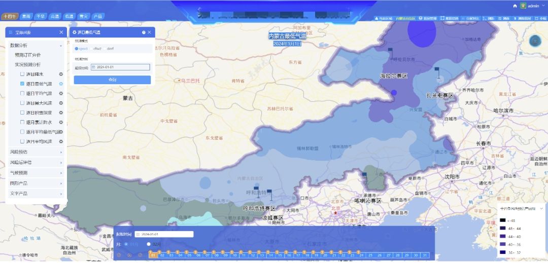
One Map of meteorological support during the 14th Winter Games
Climate forecast leaves more time for event security decisions
Sudden weather will not only affect the event, but may also pose a threat to the health and safety of athletes. Therefore, predicting disaster weather is one of the important functions of the system.
To assist with decision-making, the climate disaster risk assessment and climate prediction system establishes extension period, month and other medium and long-term prediction indicators, and predicts extreme weather such as strong winds, low temperatures, and snow disasters. The prediction results are fed back to relevant units 15 days to 30 days in advance so that they can formulate response plans calmly and effectively to reduce losses caused by extreme weather factors.
In addition, based on the prediction products, the system can also provide effective reminders to participating athletes, spectators, etc. in advance, and assist in the adjustment of transportation, cold protection, accommodation arrangements and other plans.
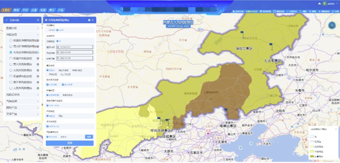
Estimated risk of strong winds around the venue
Traffic forecast provides comprehensive event traffic guarantee
In addition to predicting disaster weather, the system can also provide early warning of traffic and road conditions during the event. The event traffic and regional traffic weather forecast service system fully combines GIS technology with traffic weather monitoring and forecasting technology, conducts in-depth analysis of road visibility, road icing, snowfall, etc. around the competition area, and provides forecasts and early warnings and other specialized services for the road network around the competition venue.
At the same time, the system also integrates diversified modules such as tourist attraction viewing, ultraviolet intensity analysis, and air quality forecasting to provide comprehensive guarantees for the 14th Winter Games from multiple perspectives.
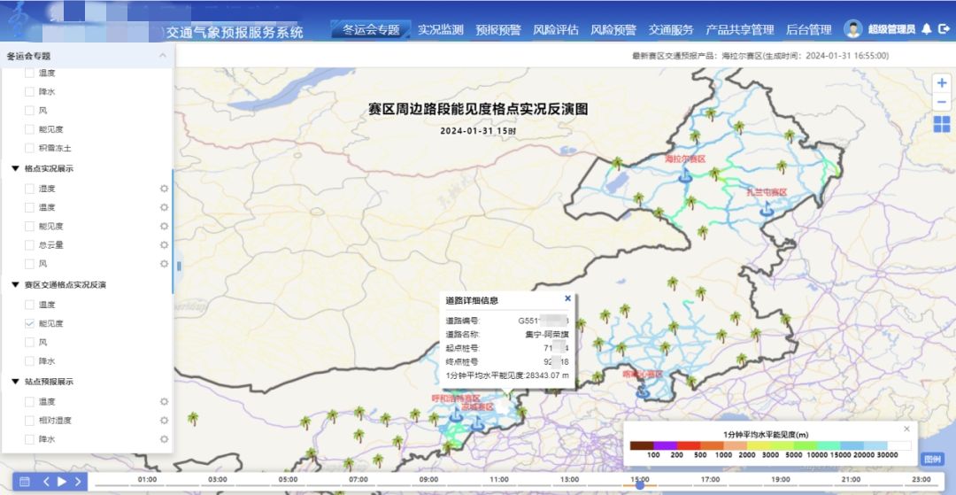
One Map of event transportation guarantee
SuperMap Water Conservancy and Meteorology BU (Business Unit) has focused on the construction of meteorological information projects for more than a decade and is committed to providing professional meteorological solutions and services to the industry. SuperMap has participated in the meteorological support work for major national and international events on many occasions, including the 2010 Shanghai World Expo, the celebration of the 100th anniversary of the founding of the Communist Party of China in 2021, and the Olympic Winter Games Beijing 2022.
In the future, SuperMap will continue to provide technical support and services for the development of world meteorological industry and meteorological support for major events through continuous cooperation and technological innovation.


