In SuperMap GIS 2023, the newly released series of products in 2023, the new version of SuperMap iMobile has achieved comprehensive improvements in map display and browsing, AR map application, dynamic plotting and deduction, cloud collaborative services, etc., assisting smart parks, land planning, bridge acceptance, and pipeline inspections, agricultural monitoring and other application construction to provide more stable and reliable mobile GIS services.
Multi-facet approach to optimize maps and enhance mobile user experience
Maps are the foundation of GIS applications, and high-performance, high-definition offline map services are a focus of mobile GIS. The new version of SuperMap iMobile continues to optimize and upgrade the map experience in terms of performance and display.
In terms of performance, SuperMap iMobile improves map browsing performance by layering drawing, increasing display frame rate, and improving reading and writing speeds. Gesture map panning is smoother and gesture map zooming is more natural without white blocks.
In terms of display, as the resolution of mobile devices becomes higher and higher, there are more and more user demand for high-definition display of maps. SuperMap iMobile optimizes the display clarity of third-party map services, such as Amap and Baidu, and supports SVG vector symbols. You can also browse lossless map symbols with high-resolution screen devices and experience high-definition map services.
Label is one of the important map elements, map labels in the new version of SuperMap iMobile display collisions with linear objects without overlapping. In applications such as transportation and pipe networks, road names and pipeline names can be accurately marked. Using label weights, we prevent important labels from not being displayed due to collisions; within the designated work area, the designated labels are highlighted.
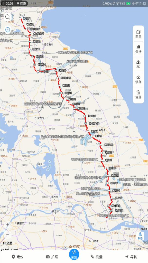
Labeling along the pipeline network
AR map application enhanced to facilitate precise operations in multiple scenarios
AR maps are based on video spatialization and use computer vision technology to integrate virtuality and reality to perform real-time geographic information visualization and intelligent geographic analysis.
The new version of SuperMap iMobile has enriched the visualization mode. Through potholes, rolling shutters, etc., you can view underground pipelines in the holes, and compare the real environment and pipeline burial horizontally and vertically. During the inspection, pipeline inspection personnel will have a clear view of the underground pipeline layout at the scene. At the same time, 3D AR integrates high-precision positioning such as CTI, Qianxun, and Hi-Tech, and improves positioning accuracy by accessing high-precision positioning equipment, making it more suitable for applications such as field pipeline inspections and building acceptance and delivery.
In addition, it also adds a new label thematic map, which supports custom styles, fixed size and non-fixed size rendering, and uses spatial coordinate avoidance and pixel coordinate avoidance to prevent text overlap. In the refined monitoring of agriculture, temperature, humidity, light, etc. are highlighted, and the parameters of each plot are all visible on the map.
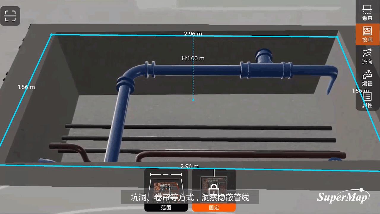
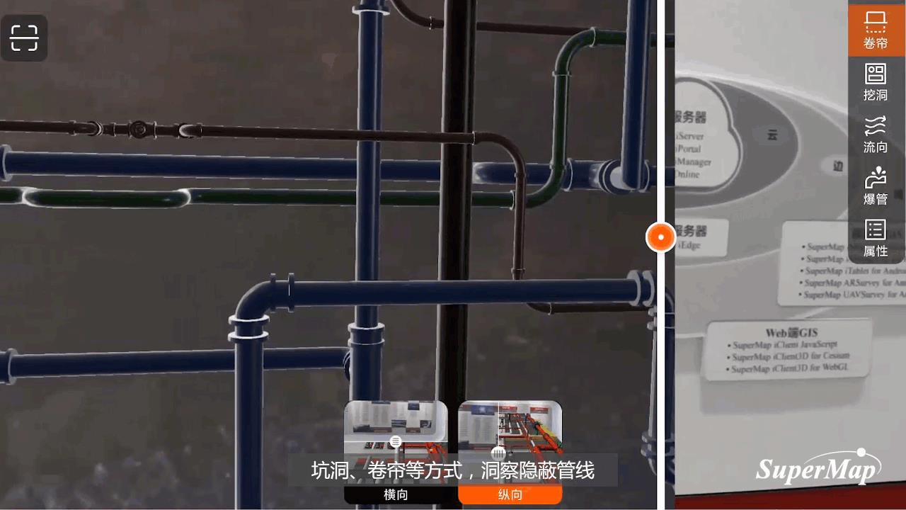

AR pipeline inspection
Extensible situation plotting to assist emergency dispatch scenarios
Situation plotting refers to plotting emergency and command plans and plans expressed in text form or on paper maps against the background of the map and realizing dynamic simulation deductions, making the plotting mapped, visualized, and dynamic.
The new version of SuperMap iMobile supports desktop-produced symbol libraries, provides standard plotting symbol libraries and armed police symbol libraries. The symbol library is extensible and can be customized according to application requirements. At the same time, on the basis of xml deduction animation, import, production, playback, and export of JSON format animation are added, and the animation format is expanded to facilitate the playback of desktop-produced plotting animations on the mobile terminal, providing service to dispatch command, emergency rescue and other applications.
Comprehensively upgrade in online services to improve business processing efficiency
Currently, more and more mobile GIS applications start to cooperate with cloud management platforms. When field inspections or verification work begin, task data are downloaded from the management platform. After the business data collection is completed, the network can be used to upload the data to the management platform in a timely manner. SuperMap iMobile has improved the upload and download performance of data services by more than five times, saving data transmission time and reducing the possibility of data loss or errors due to network problems.
Using the powerful analysis and computing capabilities of cloud servers, the new version of SuperMap iMobile can also perform route analysis, travel agent analysis, logistics distribution analysis, etc. In this way, the analysis can be realized not only on the mobile terminal, but also through the method of " mobile terminal application-server terminal analysis-mobile terminal display ", and can analyze transmission lines, etc. in power projects.
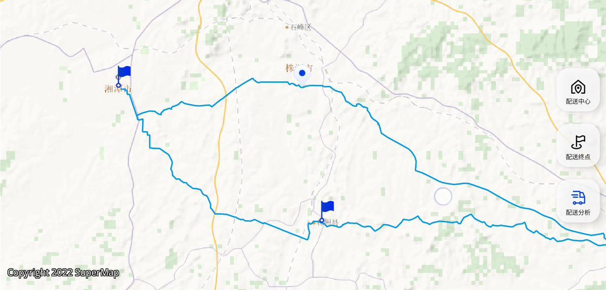
Logistics analysis services
Enhanced traditional capabilities and compatibility to serve more analysis needs
In addition to the above new features, SuperMap iMobile continues to upgrade in terms of data analysis, path navigation, 2D and 3D integration, and so on. First of all, the data analysis capabilities are enhanced, and terrain surface area analysis, slope analysis and slope aspect analysis are added to assist land planning and other applications. Secondly, it improves path analysis and navigation, adds support for obstacle points, and is more suitable for the special navigation needs of vehicles such as trucks. Thirdly, the integrated application of 2D and 3D is more in-depth. The 3D scene can directly load the 2D map to serve urban planning. The 2D map can view the layout and road network, and the 3D scene can view the street situation and details.
Summary
SuperMap Mobile GIS has always been committed to providing users with more advanced and practical mobile GIS technology and services. We will continue to upgrade product functions and improve product experience based on market demands, and continue to provide users with more professional, more stable, more efficient, more practical mobile GIS products and services. Welcome to SuperMap official website to download and try SuperMap mobile GIS product development platform.


