With the rapid development of remote sensing technology, the means of obtaining remote sensing images have become increasingly abundant, the amount of image data has exploded, and image applications have been put into use across all walks of life. As a result, how to efficiently manage massive remote sensing image data has become an industry problem. Users often face issues like duplicate data storage and difficulty in data retrieval in image management applications, drawing attention to a series of problems in data application, release, and data services in the industry.
SuperMap iServer, a server platform launched by SuperMap integrates image data processing, data management, service publishing, data application, and intelligent interpretation services in one platform, realizing the integration of the entire image processing and effectively solving many problems in image applications. This article focuses on a key role in the whole process of image application - SuperMap iServer image service. It realizes efficient and unified management and rapid release of multi-source and massive images, enables barrier-free data connection in all aspects of the entire process, and helps the industry build an integrated image application system.
Efficient and unified management of massive images
Image service provides a new model for the management and release of massive image data. Images are managed through services, and organized according to the classification of different collections. The images are ultimately managed by mosaic datasets. The mosaic data collection is an image data management model uniformly used in the SuperMap remote sensing and GIS integrated product system. It gives the image service excellent data management capabilities.
The image service can manage multiple storage media including local file systems, shared directories, object storage, and FTP servers, and multiple formats of PB-level images. It also supports the management of primary satellite data products. The image service uses metadata to manage images. There is no need to change the original storage location of the image, and no need to store the image twice. This avoids the problem of repeated data storage caused by unified management of images stored in different positions, and solves the problem of low efficiency of image storage management.
Convenient and easy-to-use image management operation
SuperMap has also provided quick publishing service to improve the ease of use of data management. Based on image services, you can manage data in an efficient way on the SuperMap iServer service management page by creating an image collection and performing simple data source configuration. The data source of the collection supports a variety of configuration forms, including: image data directory, image file list, and existing mosaic data collection results.
In actual business scenarios, the image management system may receive new images regularly and update them frequently. For example, the remote sensing production results data management platform will receive new results data from time to time. Managing the incremental images manually processed is indeed a lot of work. To improve such experiences, we provide the monitoring data directory and the ability to automatically add new images, which can be realized by simply turning on automatic addition during the process of configuring the data collection.
At the same time, the image service also opens a data management API, which is an OpenAI application programming interface that follows the STAC (SpatioTemporal Asset Catalog, SpatioTemporal Asset Catalog) API specification. It can realize the web-end development of image service management capabilities, which is conducive to the docking of industry business systems with SuperMap iServer image service and enables convenient, efficient and unified management of images.
“Efficient management and instant release”service
Through the image service, you can publish image map services without slicing. Images can be dynamically mosaic-displayed and support display style configuration, which takes effect in real-time. The slice-free publishing capability of the image service can meet the needs for rapid image publishing and preview in scenarios with high frequency of data updates, rapid changes in display styles, and low concurrent visits.
For scenarios with low data update frequency and high concurrent access, we also provide solutions. You can enable silent slicing of image service to generate image map tiles. When dynamic caching mode is enabled, Image Service can provide tile services, meeting the performance requirements of high concurrent access. In addition, image service silent slicing supports scheduled tasks, which makes it easy to select a time period when server resources are relatively idle and then complete slicing tasks that consume large resources.
Service types for multi-scenario applications
The image service provides multiple service types such as STAC API, tile, WMS, and WMTS. Among them, the tile service can return tile resources with specified row and column numbers, filter conditions and display styles to meet the filter display and real-time rendering requirements of image map services; the WMTS service can facilitate third-party client systems. The WebGL three-dimensional scene can dock with image services and become basemap service. WMTS service also supports pre-caching capabilities to ensure the rendering efficiency of image basemaps.
The image service has multi-temporal image management capabilities, and the WMS service is suitable for visual display of temporal data playback.
Image data retrieval and download service
The imaging service provides an out-of-the-box image data retrieval page. It supports multiple query and retrieval methods, and query results previews. It also supports configuration data download, and provides retrieval result download services. In actual business scenarios, the use of more complex retrieval conditions may be required. For example, in the management of satellite data products, it may be necessary to use multiple conditions such as satellite sensor types, shooting time, cloud coverage, etc. to query target images. In this case, you can expand and develop data retrieval applications that meet business needs through the image service API, and further solve the problem of difficult data retrieval on the basis of unified management of image data.
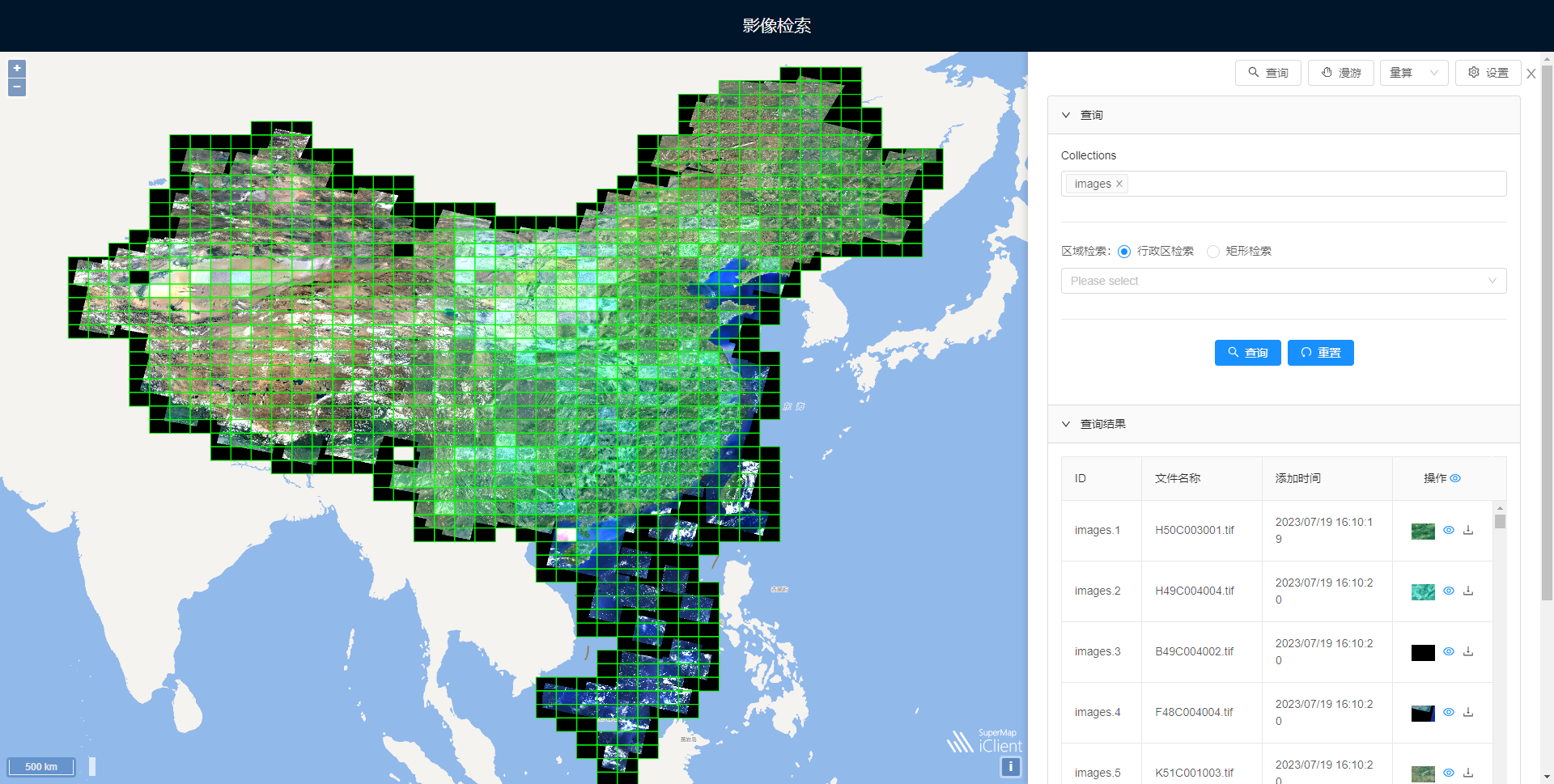
Retrieval preview of image service
Opening up all image applications
The above mainly introduces how image services can effectively solve many problems faced by massive image management and release in industry applications, and achieve integrated data management and service release. However, integrated full-process image applications also include data processing and other important application aspects. SuperMap iServer provides image processing GPA services and machine learning services of intelligent interpretation. These services support the ability to obtain and process data from imaging services, truly opening up the full range of image applications from data management to data processing, data applications, and intelligent interpretation.

Map service for analysis results of buildings extracted from images
Summary
SuperMap iServer image service has the capability of convenient, efficient and unified multi-source massive images management and rapid service release, solving multiple user pain points in image management. In addition, based on the unified image data management model of the SuperMap GIS product system, SuperMap iServer image service opens up the process from image data management to application, and even has the ability to connect to other SuperMap GIS products to carry out image processing business. This helps form an application closed loop of "instant production and management, immediate management and deployment, and immediate deployment and use" of images, facilitating the implementation of integrated solutions for full-process image applications.


