SuperMap iClient JavaScript is a GIS network client development platform built on a modern Web technology stack. It integrates leading open source map libraries and visualization libraries to quickly achieve beautiful and smooth map presentation and spatial analysis on browsers and mobile terminals.
In 2023, we launched a new open-source map library MapLibreGL in SuperMap iClient JavaScript 2023, providing a more comprehensive solution for WebGIS development. It also provides deeper support for spatial data formats and map coordinate systems for further enhanced Web mapping capabilities.
A brand-new map library MapLibreGL, which can smoothly migrate the MapboxGL solution
In terms of open-source map libraries, since the MapboxGL v2 has been commercialized, the MapLibre organization has launched the Map Libre GL JS, an open-source branch originated from the Mapbox GL JS v1. Therefore, SuperMap iClient JavaScript 2023 supports MapLibre GL JS on the basis of the original map library, launches a new open-source map library iClient for MapLibreGL, and provides APIs for accessing a series of services such as SuperMap iServer maps, data, spatial analysis, etc., and visualization-related APIs. MapLibreGL is fully compatible with MapboxGL JS v1 and can easily and smoothly migrate MapboxGL solutions in iClient to MapLibreGL, thus meeting the needs of users to use MapLibreGL map libraries in their projects. At the same time, MapLibre GL JS accelerates the rendering of vector tiles through hardware and can quickly display maps in the browser.
A new Web symbol library is added to provide consistent symbolic drawing capabilities at the both front and back ends.
In terms of web mapping, SuperMap iClient JavaScript 2023 launches a Web symbol library, which covers most of the basic symbols in the desktop product SuperMap iDesktop/iDesktopX, which can achieve the same mapping effect as the desktop product. Currently, Web symbols can be quickly drawn through iClient for MapboxGL. It also supports custom symbol styles to meet users' needs for in-depth customization of symbols and achieve more diversified Web mapping effects.
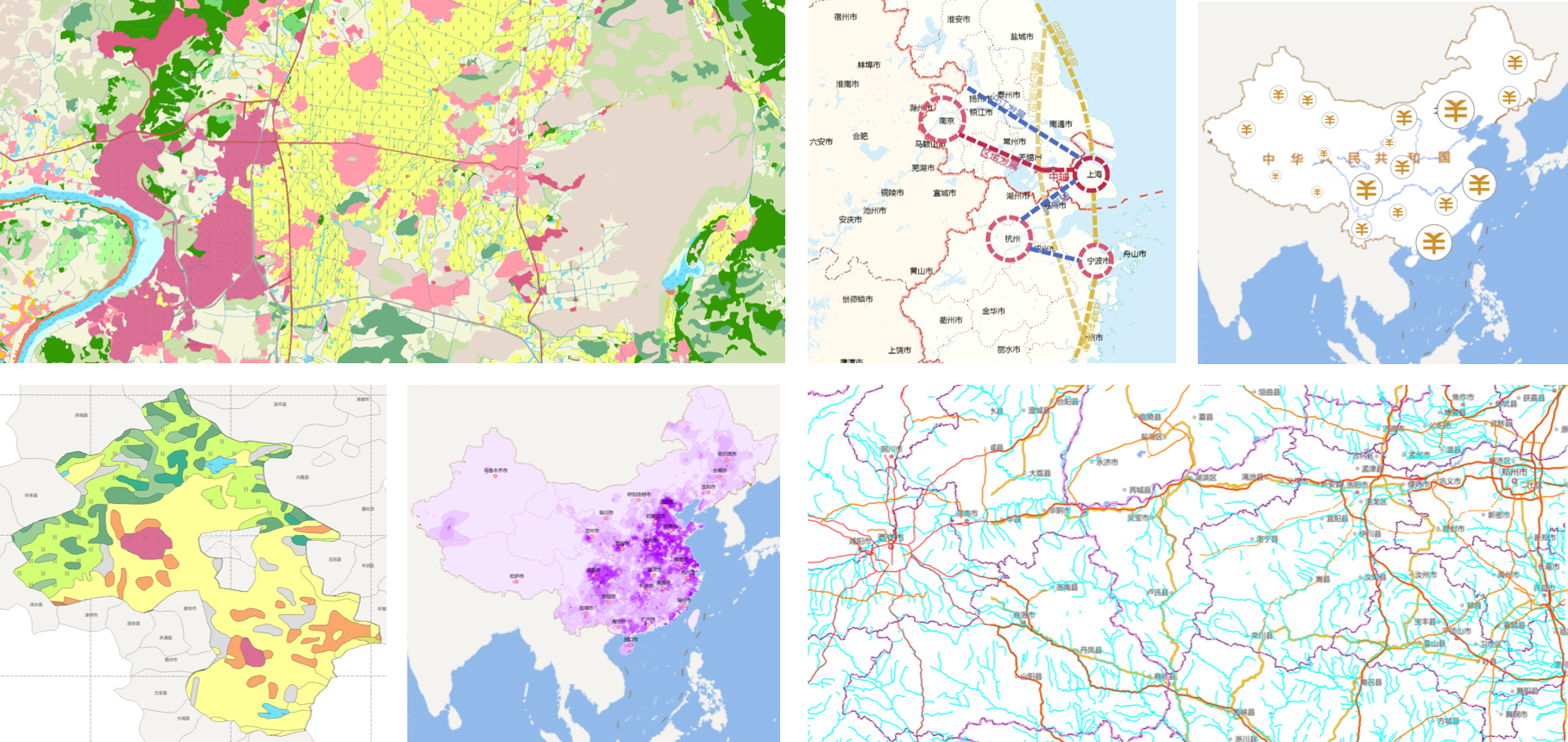
Example of rich web symbol mapping
To help users quickly get started with Web symbol mapping, iClient for MapboxGL and Map LibreGL provide Web symbol library examples and Web symbol editor examples. The Web symbol library examples visually display all current Web symbols. With a click on any symbol, you can view its implementation code and intuitively understand how the symbol is implemented; the Web symbol editor examples are used to interactively edit symbol styles and browse the effects of the symbol on the image.
New support for cloud-native vector exchange format to easily access GIS data on the cloud
SuperMap iClient JavaScript 2023 adds support for the cloud-native vector exchange format (FlatGeobuf), which can help directly access the FlatGeobuf format files returned by cloud storage and SuperMap iServer services. It supports streaming transmission and rendering, and supports style modification.
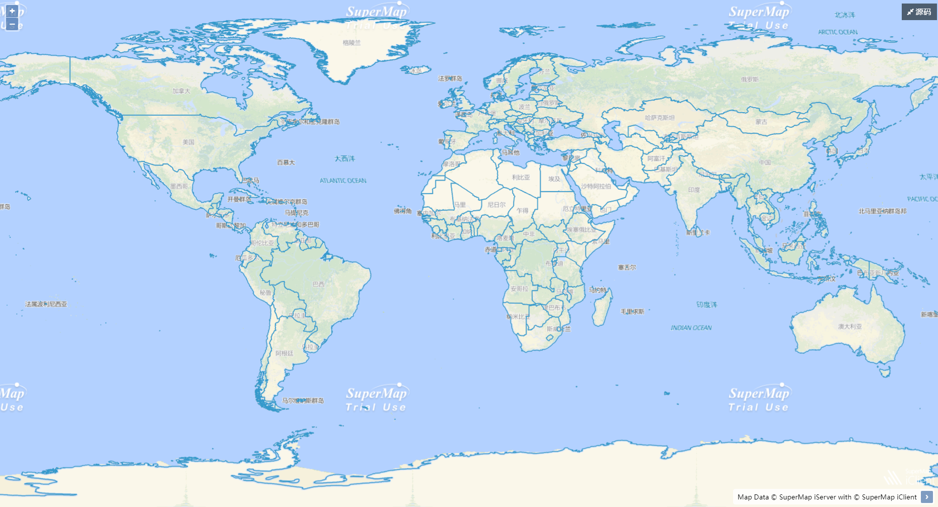
Rendering effect of FlatGeobuf data in iClient
The FlatGeobuf format has the characteristics of small storage volume, fast reading and writing speed, and strong support. Compared with traditional Shapefile and GeoJSON formats, FlatGeobuf format can load more data on the Web and has higher query and rendering efficiency, which can greatly improve the display experience of large-scale data on the Web.
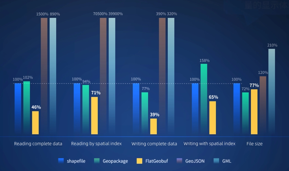
Performance comparison between FlatGeobuf format and commonly used storage formats
In order to further optimize the browsing experience of massive FlatGeobuf data on the Web, SuperMap iClient provides two data loading methods: full loading and on-demand loading. Using the full loading strategy, you can directly load complete data; using the on-demand loading strategy, you can load the data only within the current visible range, and it can be loaded immediately as the visible range of the map changes, achieving smooth display of data.
Enhanced support for multiple coordinate systems to render most geographical/projected coordinate system maps
Through further customization of MapboxGL, iClient for MapboxGL can render maps in almost all coordinate systems, including geographical coordinate systems, projected coordinate systems, local coordinate systems and other standard coordinate systems. Whether it is SuperMap iServer map service or OGC WMTS/WMS service, and whether it is vector tiles or raster tiles, the maps in the specified coordinate system can be loaded through simple coordinate system parameter settings.
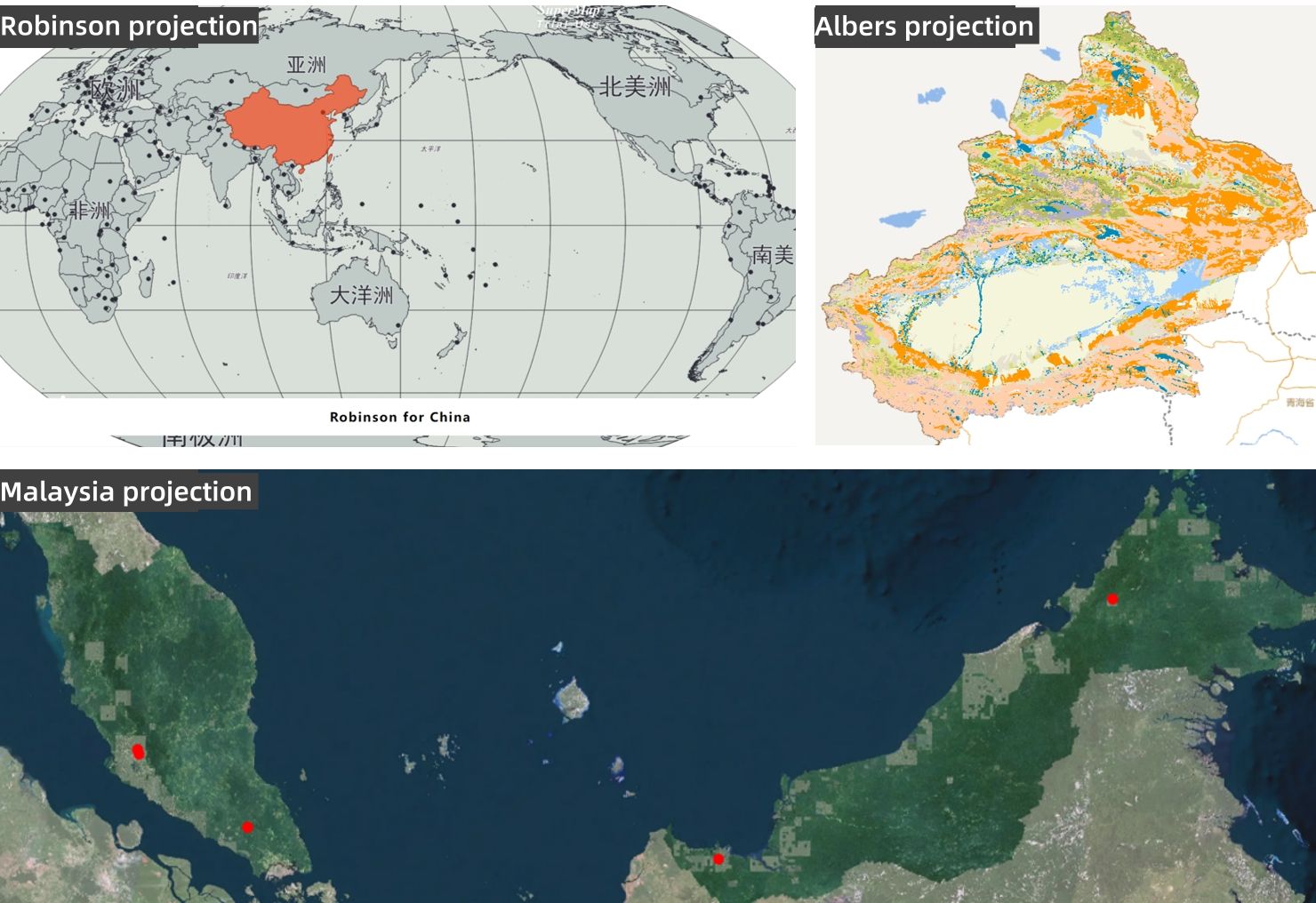
Rich customized projection examples
Geographical knowledge graph Web visualization for quick map generation with one line of code
SuperMap iClient JavaScript 2023 supports docking with the knowledge graph service provided by SuperMap iServer, which can realize geographic knowledge graph Web visualization. With just one line of code, you can quickly create a map. It also supports graph style editing, entity relationship exploration, and graph data query on the Web, and provides a series of interactive event-related APIs to achieve faster and more accurate data correlation reasoning operations and hidden relationship mining, which facilitates project analysis and decision-making.
In SuperMap GIS 2023, SuperMap iClient JavaScript launched MapLibreGL, a new open-source map library based on the original map library. It also provides more supports for spatial data formats and map coordinate systems, and has significantly enhanced web mapping capabilities. The WebGIS technology system is now richer and more comprehensive. The new features of the SuperMap iClient JavaScript 2023 version have been launched simultaneously on the official website, welcome to have a try.
SuperMap iClient JavaScript site address: https://iclient.supermap.io/en/web/index.html


