Currently, mobile GIS has been widely used in various industries. To meet the in-depth business requirements such as cloud integration, offline services, intelligent analysis, and information security, SuperMap Information (one of SuperMap’s subsidiaries) built an intelligent mobile GIS development framework based on SuperMap iMobile (hereinafter referred to as the "mobile GIS development framework") and is committed to promoting the development of mobile GIS applications in the fields of natural resources, housing and construction, smart cities, etc., providing technical support for mobile and intelligent application in different scenarios.
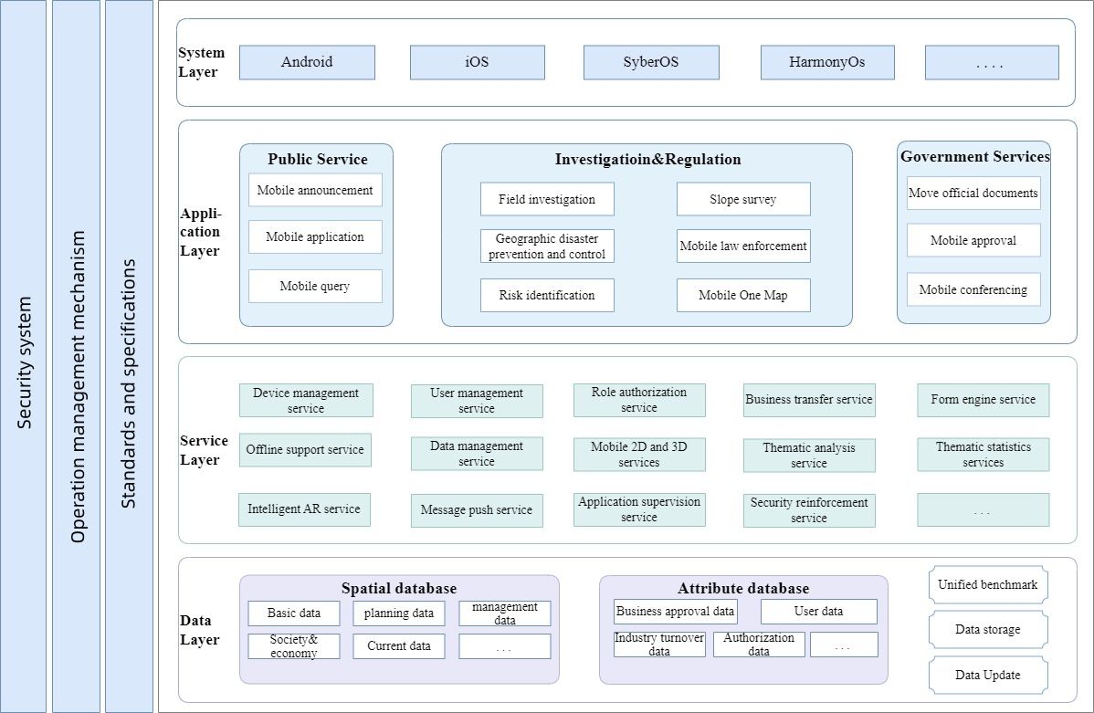
SuperMap Information Intelligent Mobile GIS Development Framework Architecture
SuperMap information intelligent mobile GIS development framework is based on SuperMap iMobile, SuperMap mobile GIS development platform. It is a mobile GIS application framework with development, operation and maintenance integrated, which can be upgraded rapidly. Using the Jetpack component library, it supports multi-language and multi-run environments (Android, IOS, HarmonyOS, SyberOS). It supports localized adaptation environment, supports cloud integration, can meet the integrated management of GIS services and data in offline/online situations, and provides a variety of data security measures.
Three major technological innovations make services faster and safer
Intelligent mobile scenarios boost service efficiency
The mobile GIS development framework combines AI technology to provide three capabilities: voice recognition, face recognition, and mobile sign-in and approval. It enhances the experience of mobile office, promotes new models of government services, and makes government affairs more convenient and efficient. In terms of speech recognition, it supports speech interpretation to solve problems such as low efficiency of manual writing and cumbersome input; in terms of face recognition, it supports face recognition verification to ensure that the identity is authentic and reliable; in terms of mobile signature, it supports handwritten signature to facilitate unified management and save office costs.
Cross-platform and multi-terminal reuse to quickly respond to business needs
The mobile GIS development framework adopts a native + H5 mixed development model, which can publish H5 pages to multiple platforms such as iOS, Android, Web (responsive), and various small programs (WeChat /Alipay, etc.), enabling one set of code to run on multiple terminals, which can save development costs, respond quickly to needs, and facilitate code maintenance.
Comprehensive security guarantee for safer information
The mobile GIS development framework mainly protects mobile application information security through the following aspects:
In terms of application security, the unified user center realizes integrated authentication management of user information in the cloud, and at the same time realizes hierarchical management and isolation of functions based on the unified authentication system;
In terms of device security, the mobile GIS framework has device authentication, scheduled data cleaning and other functions, which can ensure data security at the device level;
In terms of data security, data encryption is used to ensure the security of data during transmission and use.
In terms of network security, mobile private network + VPN + firewall and other methods are used; in terms of operation and maintenance security, we compile security operation and maintenance plans, regularly carry out security detection and automated vulnerability scanning to proactively discover security vulnerabilities in a timely manner, and achieve closed-loop management of the entire life cycle of vulnerabilities.


