The integration of GIS and knowledge graphs
Knowledge graph is a brand-new way of expressing data relationships, which can associate everything into a unified semantic network. Compared with conventional structured data, it can query and explore data relationships more efficiently. Integrating GIS and graphs allows geospatial data to be displayed in a more vivid way. SuperMap iDesktopX launched geographical knowledge graph module which supports direct connection to graph databases and provides integrated storage capabilities for graph and spatial data. Entities and relationships can be quickly constructed through processing automation tools; it supports graph visualization so that graphs and maps of entities with spatial attributes can be browsed simultaneously; it also supports spatial query and analysis of entities with spatial attributes. Applied in new basic surveying and mapping, real estate registration and other businesses, it can assist with relationship construction, expression, management, mining and application of geographical entities, allowing users to gain insights into the relationships between geographical entities more conveniently and efficiently.
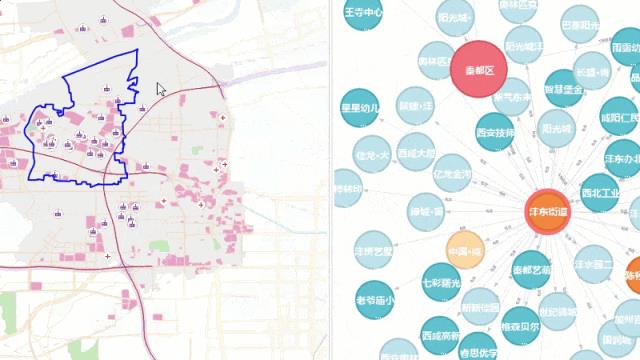
Geographic knowledge graph creation and associated browsing
More comprehensive data migration, ensuring efficiency and safety
The data migration function can efficiently migrate data, maps, layouts, tiles and other resources from different GIS platforms to SuperMap platform, which can help retain original data and map results as much as possible. SuperMap iDesktopX has added support for generating migration reports when migrating MXD data. You can check map layers, map parameters, number of data sets, coordinate systems and other information before and after migration. At the same time, a new MapGIS data migration function is added, which supports the migration of maps, symbol libraries, and data in MapGIS 6X and MapGIS 10 series to the SuperMap platform, ensuring the accuracy of data migration and restoring the original effect of map results to the maximum extent.
High-quality image data production, improving production efficiency
In order to break the "separation" between remote sensing and GIS, shorten the time from image acquisition to application, and improve the reliability and availability of remote sensing data, SuperMap iDesktopX is equipped with the capability of producing DOM, DSM, and DEM data throughout the whole process of satellite remote sensing image based on the core algorithm of photogrammetry. Integrated with AI, Accelerated Parallel Processing and other techniques, it improves the image processing geometric accuracy and digital surface model quality. At the same time, remote sensing and GIS integration and automated processing can accelerate the process from data to application and realize the ability to produce remote sensing image data “today” and apply it “tomorrow”.
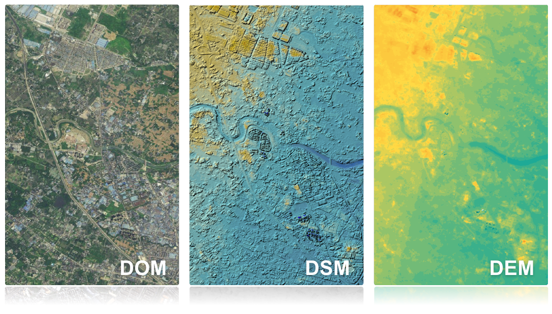
Remote sensing image data products
Upgraded multi-dimensional interactive experience to make product easier to use
SuperMap iDesktopX has been upgraded to improve interactive experience. The newly launched dark and light theme styles make the entire interface cleaner and improve the overall aesthetics; it improves the usability of the SQL query function, supports viewing function help, and provides semi-automatic and manual SQL expression input to meet different input requirements; the toolbox search function in processing automation is optimized, and model search and other functions are added to quickly locate the tool positions in the toolbox and model.


