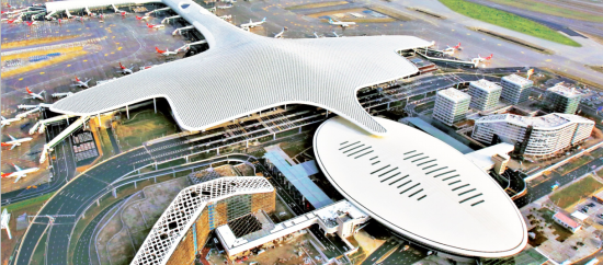
Shenzhen Bao'an International Airport was built in 1991. For more than three decades, the pace of construction has continued to accelerate. With more and more underground pipelines laid, the contradiction between the underground pipeline construction and aboveground management has become more and more prominent: the airport lacks complete and updated basic data of underground pipelines. The "zipper" phenomenon in road construction and underground pipeline accidents caused by blind design and construction occur from time to time, which not only cause huge economic losses, but also bring hidden dangers to the safe operation of airports.
In view of the problems existing in Shenzhen Airport's underground pipeline survey and detection and the integrated management of pipeline information, such as low operating technology, backward information management and imperfect management mechanisms, SuperMap took the lead and developed "the Comprehensive Management System of Shenzhen Airport Underground Pipeline" and "Public Service Platform of Shenzhen Airport Geographic Information". The platform and the system have been approved by the expert group and put into use at Shenzhen Bao'an International Airport. The project comprehensively applies advanced technologies such as surveying and mapping, geophysical prospecting, and GIS, integrates advanced management concepts, proposes a new model of pipeline census and information management, realizing comprehensive and dynamic management of pipeline information.
Multi-source data collection and fusion
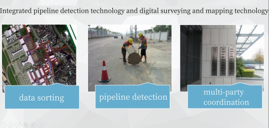
The project takes the underground pipeline management system as the core. It uses GPS technology combined with data collection and data processing methods to establish a control network. It uses integrated pipeline detection technology and digital surveying and mapping technology to simultaneously collect the spatial coordinates, attribute data, surveying and mapping strip topographic maps of underground pipelines, and compile underground pipeline maps, laying a solid foundation for flexible management of the airport.
Using SuperMap SDX plus spatial database engine technology, the project integrates Shenzhen Airport topographic maps, high-resolution remote sensing images, above-ground 3D models and underground pipeline data to achieve multi-source heterogeneous data fusion and management.
"One map"of airport geographical information
The construction of the project integrates various thematic geographical information data such as airport topographic maps, above-ground 3D data, underground pipeline 3D data, remote sensing images, DEM, place names and addresses, etc., forming a "one map" of Shenzhen Airport's geographical information and realizing effective integration of the airport pipeline life cycle information resources.
2D and 3D integration to efficiently improve pipeline management
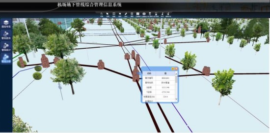
SuperMap 2D and 3D integrated GIS technology is used to quickly generate 3D scenes from pipeline census data through 3D automatic pipeline processing tools, and realize the integration of 2D and 3D pipeline data in data models, data storage solutions, data editing and management, visualization and analysis functions.
Shared, diverse and integrated applications
The project establishes an underground pipeline data management service center, pipeline database, data exchange platform and airport local area dedicated network, and then interconnects the pipeline data management center and professional pipeline ownership units by centralized management and information sharing of underground pipeline data. In this way, the modernized management and diverse application of pipeline information.
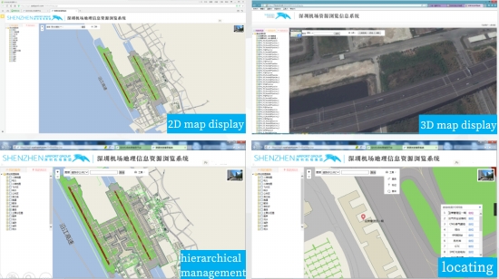
Based on the service-oriented architecture, an airport geographical information public service platform has been established. It connects to the Shenzhen Airport intranet system, realizing the sharing and exchanged of pipeline information and geographical information in an integrated way, and integrated application on the Web, PC and mobile terminals.


