In June this year, SuperMap released a new version of SuperMap Online, which has been significantly upgraded in terms of GIS service release and management, expansion and development capability support, organizational management and collaboration, and industry solutions, making it an organization-level online GIS platform. What new capabilities does each part of the new product provide? What value does it bring? This article will introduce to you in detail.
Cloud GIS server publishes and manages GIS services in public network with one click
Servers are an important infrastructure for GIS applications. In the early days, enterprises used self-built servers, which had high costs, fixed configurations, and complicated installations, hindering the migration of GIS applications to the cloud. SuperMap Online integrates the key capabilities of cloud services to create a cloud GIS server (shared version). With simple configuration on the browser, you can build public GIS services, manage service access rights, and monitor the real-time access to services.
After uploading GIS data, users can publish multiple types of GIS services with one click, view them online, or download code packages for local development. In addition, it also supports migrating local services to the cloud in a wizard manner and allows them to be used and managed uniformly.
This method will greatly reduce the initial construction cost of the project, and alleviate the problems of high software and hardware prices, long deployment cycles, and troublesome operation, maintenance and upgrades. In this way, users can focus more on building core businesses and quickly run GIS applications on the cloud.
The new version of the development center provides personalized application assistance
SuperMap Online continues to improve its expansion and development capabilities, further improves the SDK and supporting documents for various terminals, and supports the rapid integration of online maps and data. It provides multiple platforms calling methods including Web platform, Android platform, iOS platform, etc. to meet users’ demands of data hosting, spatial analysis, and location analysis.
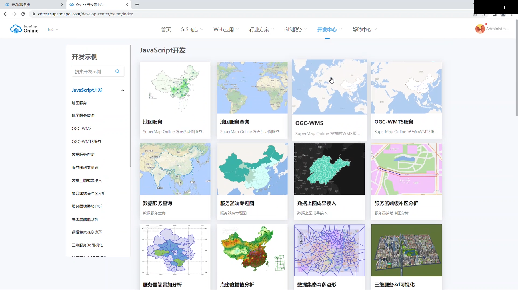
▲Development example of development center
In this way, users no longer need to purchase, install, and maintain a GIS server or repeatedly develop GIS services. They can integrate common GIS capabilities into their own projects and build GIS applications more efficiently.
Enhanced organizational structure management for multi-user management and collaboration
Multi-user collaboration has always been a "pain point" for organizational users. If not managed in time, enterprises efficiencies are hard to be improved. The new version of SuperMap Online can better respond to the multi-faceted needs of enterprises, build a government-enterprise organizational structure, improve the enterprise's ability to operate in multi-user scenarios, and support collaborative operations across organizations, departments, and applications.
Users can log in to the government and enterprise account, select "Member Management" > "Organizational Structure", and establish an organization according to the enterprise structure. It supports adding members through links and searches. After importing enterprise members, it supports assigning roles, cloud service quotas and base product software licenses to them. After members are assigned roles, quotas and other resources, they can also perform flexible operations such as modification and deletion.
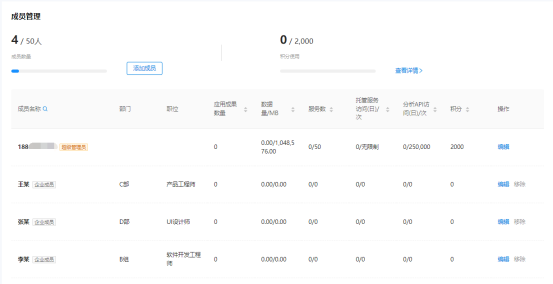
▲To add, delete, modify and check member information
The new version of SuperMap Online has enhanced the organizational structure capabilities of the government and enterprise version, improved enterprise operation efficiency and enterprise multi-user collaboration scenarios, making collaboration more concise and clearer, and management more efficient and faster.
New industry solutions for you to quickly master new cutting-edge GIS capabilities
The new version of SuperMap Online has added online industry solutions, applying GIS cutting-edge capabilities to various industry scenarios. Without the need to download and install software, you can experience solutions in remote sensing AI, real 3D scenes and other fields online, and quickly master the new cutting-edge capabilities of GIS.
1. Remote sensing AI solution: based on artificial intelligence theories such as machine learning and deep learning, it implements a series of GeoAI functions and provides intelligent interpretation tools for remote sensing images such as target detection, ground feature classification, and object extraction. 2. Real 3D scene solution: based on the integration of 2D and 3D, it integrates game engine and other technologies to comprehensively improve capabilities such as super data fusion, high-reality rendering, and immersive experience to create a real 3D scene intelligent hub. 3. UAV + GIS solution: Utilizing the advantages of UAV + GIS in spatialization in real-time, 2D and 3D map linkage, video + GIS enhancement, etc. to provide complete solutions for field mapping, information extraction, and emergency rescue. 4. Smart park solutions: based on the basic geographical information database and spatio-temporal information database, it provides application solutions such as smart park operation management, security emergency management, and indoor and outdoor integrated navigation.
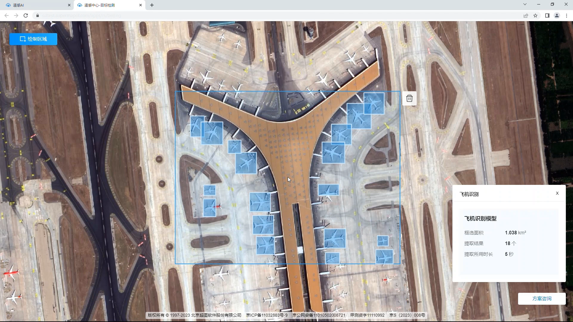
▲Remote sensing AI solution
Richer GIS resources and more convenient resource creation tools
The sharing and reuse of GIS resources can promote the rapid construction of GIS applications. After obtaining the resources, users only need to make simple adjustments in SuperMap Online to build their own personalized applications, which greatly shortens the production cycle. In addition to providing classic GIS resources such as data, services, maps, 3D scenes, data insight reports, and large-screen visualizations, the resource store in SuperMap Online also supports more types of resources, such as symbol libraries, cartographic templates, and desktop plug-ins, demonstration programs and instruction documens to provide users with a richer GIS resource library.
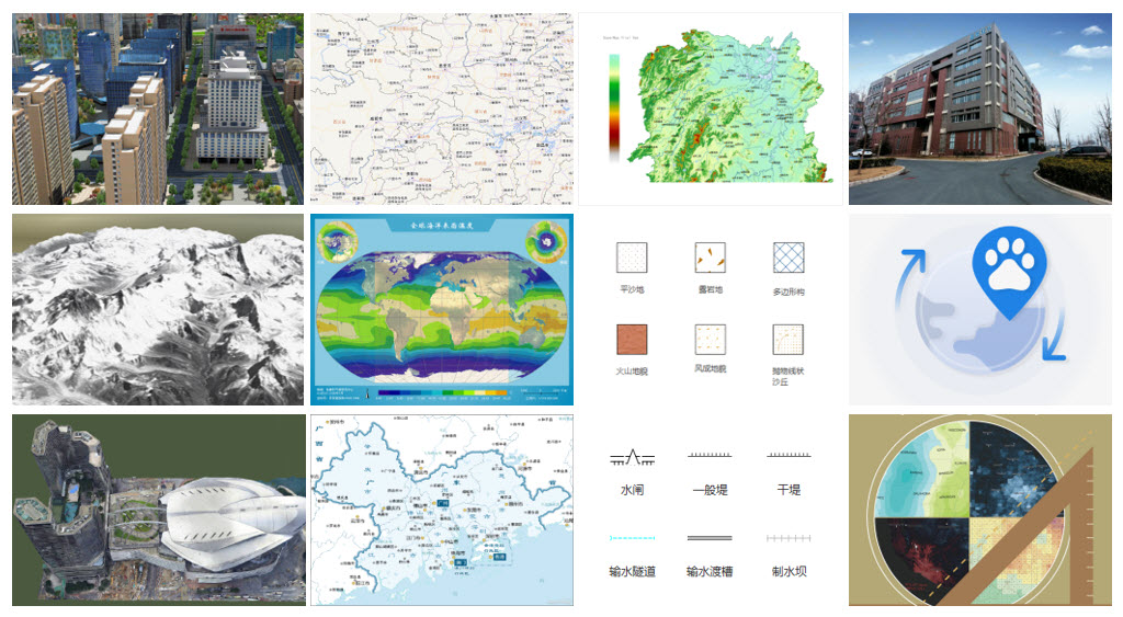
▲A richer GIS resource library


