China is one of the countries with the most serious natural disasters in the world. There are many types of disasters distributed over a wide area in China with high frequency and causing heavy losses. The government has proposed to improve meteorological disaster prevention and reduction capabilities, establish risk assessment models for different disaster-bearing bodies and digital analysis application of national meteorological disaster risks, and improve support capabilities of meteorological disaster risk management.
Relying on multi-source data fusion and big data technology, superMap's integrated platform of meteorological disaster gathers multi-source disaster data, industry data, Internet data, and other multi-channel meteorological disaster data, meteorological observations, predictions, disaster processes, inundation data, and other disaster factors, hidden danger points, early warning points, population, GDP and other carrier information to form a meteorological disaster risk big data center and implement more than 100 professional model algorithms. It has built a unified structure and highly intensive meteorological disaster risk management platform, enabling disaster risk online analysis, production, and application services throughout the whole business processes for multiple disasters such as heavy rains, floods, droughts, typhoons, high temperatures, low temperature freezes and other disasters.
The platform adopts the "one map" technical framework to integrate multi-element, multi-time, and multi-regional disaster data. It integrates disaster risk information based on space, time, disaster, business, and product dimensions, and integrates various dynamic meteorological disaster risks by correlating different disaster weather via spatial elements to evaluate business-related information. The platform can serve as a data platform, business platform, and research platform to support meteorological disaster risk management and natural disaster prevention, providing decision-making support for disaster monitoring and identification, impact assessment, risk estimation, and risk zoning.
Meteorological disaster risk spatiotemporal big data center
The platform enables multi-source disaster data collection, quality control, data management, data monitoring, and data services. The services include a system that can automatically collect and process data in the background based on visual modeling technology, and manual data collection, reporting, and management based on the Web, achieving automatic collection, processing, and calculation of meteorological observation and prediction, disaster processes, disaster risks, and other data. The system can capture multi-source heterogeneous data through data acquisition and conversion, and perform format fusion and conversion of system data based on the data format of the big data center so that the data conforms to the storage strategy of the big data center and can be shared and applied based on a unified service interface.
The data resource management function realizes metadata-driven data storage and management through the disaster risk big data resource directory. Data monitoring supports real-time monitoring of the total amount, increment, quality, and collection and production of data.
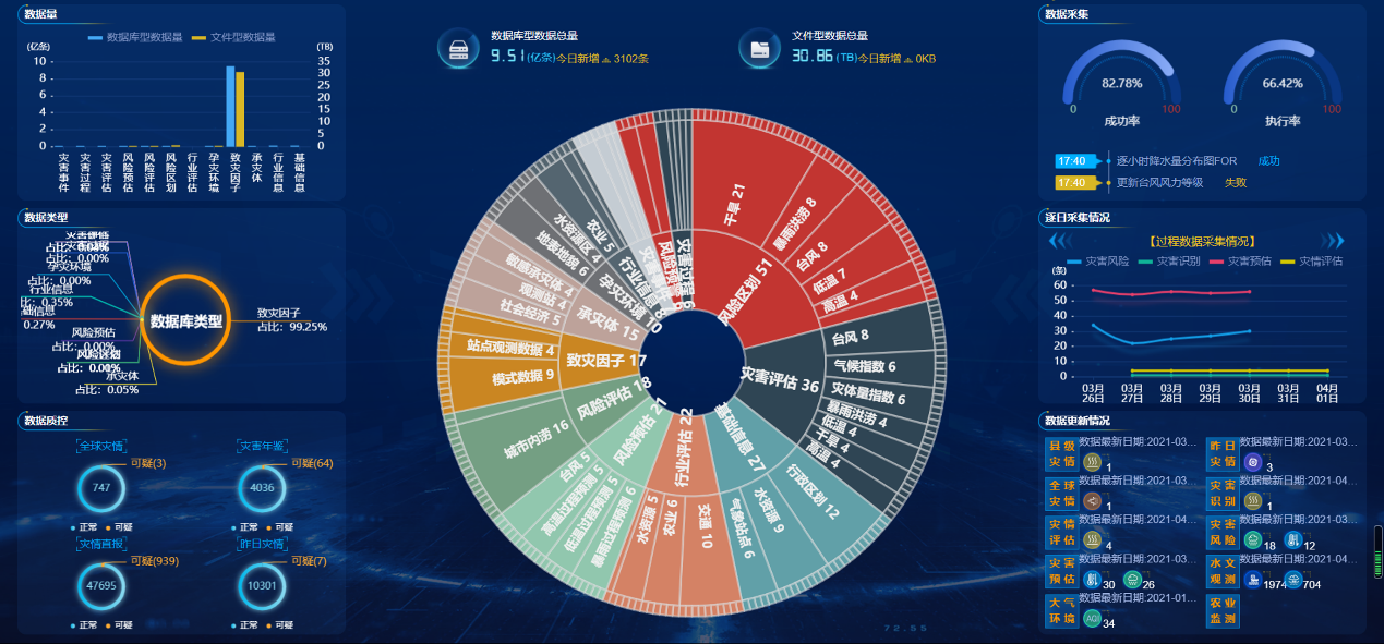
Multi-source disaster data
Multi-element, full-process meteorological disaster risk management in one map
The platform adopts the "one map" technical framework to integrate multi-element, multi-time, and multi-regional basic geographical data, disaster-producing environment data, disaster-causing factor data, disaster-bearing body data, risk zoning/assessment data, and disaster data. It can assess business-related information through spatial elements to correlate different disaster weather and integrate various dynamically changing meteorological disaster risks. The platform uses a GIS map as the main line to comprehensively integrate meteorological disaster risk management information through the five dimensions of disaster type, business, product, time, and space.
At the horizontal disaster dimension, it can support meteorological disaster risk management such as heavy rain and flood disasters, drought disasters, typhoons, high temperature disasters, and low temperature disasters; the vertical direction is based on business lines, including disaster monitoring, disaster impact assessment, disaster pre-assessment, and disaster early warning, risk zoning, basic information services supported by the system and other functions; in the temporal dimension, the data, products and functions of the climate business product sequence are effectively integrated through the concept of timeline, such as the business analysis of heavy rain process since 1951, the daily precipitation sequence since 1951 and other information; from the spatial dimension, through GIS spatial visualization technology, different business data, functions, and algorithm results can be organically integrated to achieve more accurate business analysis and generate richer business products; from the business product production dimension, through online business production, the output of any intermediate results of the business analysis in the form of products can be realized to support the business work system.
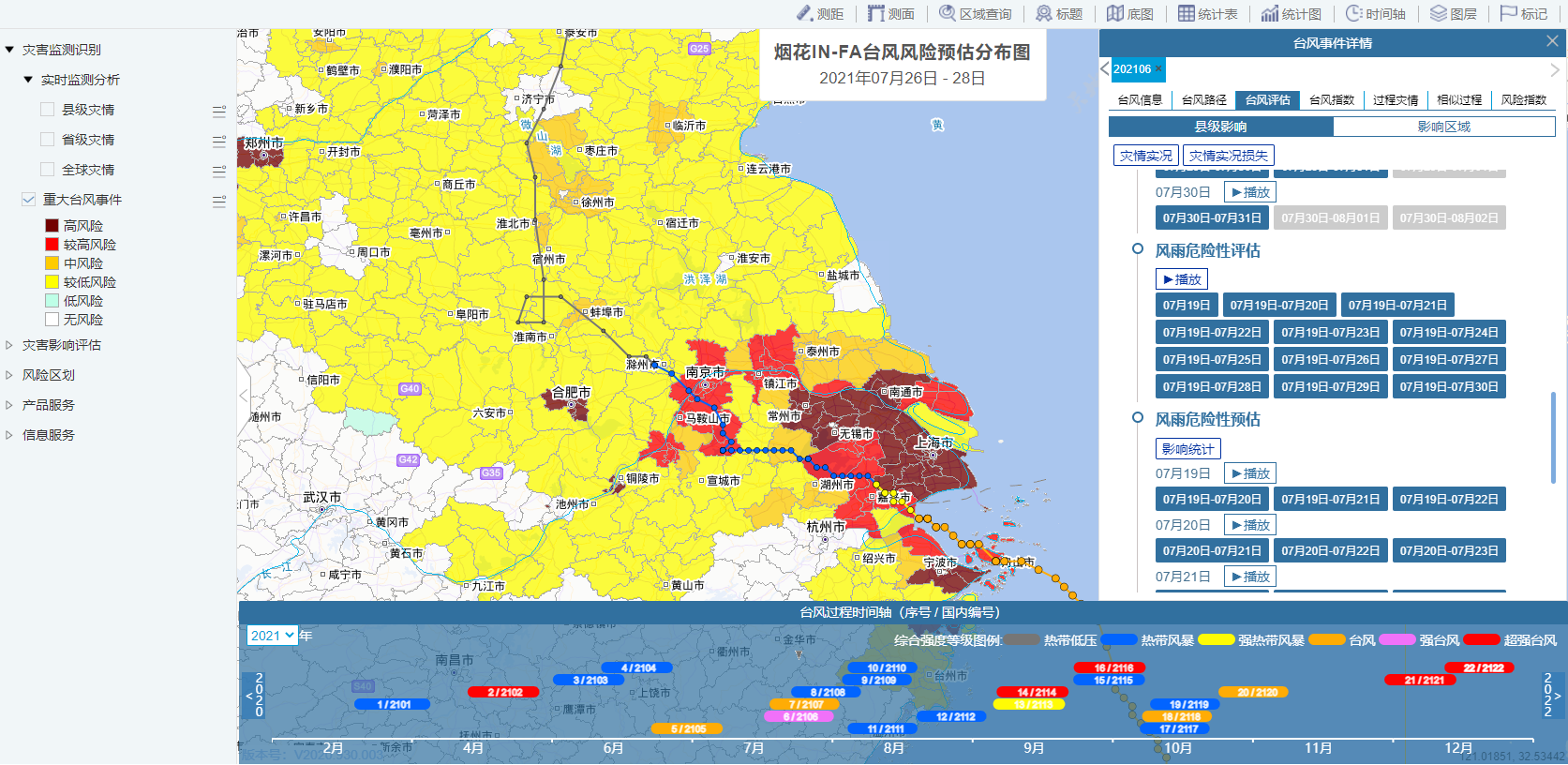
Meteorological disaster risk management
Automated and interactive meteorological disaster risk business product-making
The platform provides an interactive production platform for meteorological disaster risk business products for business personnel and supports the production of refined, quantitative, and objective meteorological disaster risk products. The platform supports two service modes: regular product production based on business templates and interactive production with flexible parameter configuration. It supports the production of static map products, dynamic thematic map products, statistical chart products, graphic report products and other types of products to meet the production requirements for various business scenarios.
Automated production calls the model in the system, directly connects the results of the disaster risk assessment model, binds the product template, and enters the automated product packaging and output links, thereby realizing the functions of regularly outputting products with fixed format specifications.
The platform provides interactive production of disaster business products for business personnel. Based on the GIS base map, different reference materials can be switched to display, and configurable editing tools are provided for users to conduct interactive mapping. The graphics can be loaded into product templates to generate graphic products. In addition, the product template can also be called to automatically generate a preliminary text product. After interactive editing, the user can save and output it into the final text product.
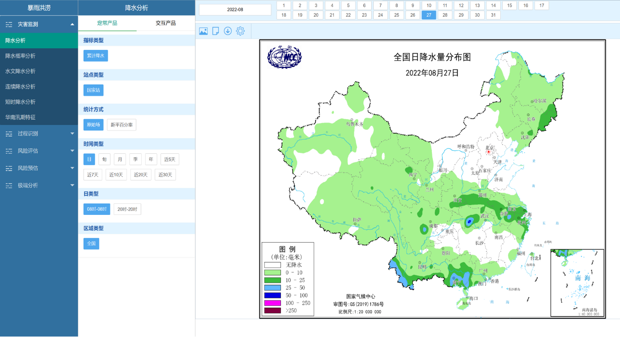
Output precipitation thematic map
Multi-industry, and refined meteorological disaster risk early warning services
Through combining with "Internet +" risk products and services, the platform realizes automated and intelligent early warning services for meteorological disaster risks such as heavy rains, droughts, and typhoons. The platform provides large-scale disaster risk early warning services based on meteorological disaster risk census results. It provides small and medium-scale refined risk warnings for cities, and also refined, objective, diversified and timely forecasting services of disaster impact and risk for specific industries such as transportation and electric power, improving the modernization of the disaster management system and governance capabilities.
Conclusion
The construction of an integrated meteorological disaster platform provides technical support for meteorological disaster monitoring and identification, impact assessment, risk estimation, and risk zoning. As a data platform, business platform, and research platform for meteorological disaster risk management business, it provides support in decision-making for disaster risk early warning services and natural disaster prevention and mitigation.


