Smart parks use next-generation information technologies such as the Internet of Things (IoT), cloud computing, big data, and geographical information integration, as well as building information models (BIM) to conduct refined management of the park. They integrate BIM and GIS technologies. And based on CIM technology, the data granularity has been further refined to a single module inside the park building, realizing the full-scale visual expression of the park, and providing important data for comprehensive management and refined governance of the park.
Based on years of experience in the field of smart application, Nanjing Guotu Information Industry Co., Ltd. (hereinafter referred to as "Guotu Information") has formed a set of highly practical and flexible smart park product solutions that serves park managers, enterprises, public employees and other groups.
The platform combines the actual development of the park and divides the park into two categories: economic industrial park and chemical park according to different focuses. Economic and industrial parks pay more attention to "intelligent operations", that is, the comprehensive management and overall operation of the park, while chemical industrial parks pay more attention to "quick linkage", that is, the park's safe production, risk monitoring, and management, emergency response, etc.
01. Integrated resource management
There is a large amount of data during the operation of the park, such as basic geographical data, special park operation data, dynamic monitoring and sensing data, etc. They are scattered in various departments and are all isolated from each other. Therefore, how to break the barriers between data from different sources, effectively connect these data, and serve park operations is a fundamental problem that the platform must solve.
To standardize and unify data, the Guotu Smart Park Platform has established a set of standard specification systems including BIM+GIS data management specifications, data update specifications, and public layer usage specifications. By collecting new data and using existing data from various departments, we gather data such as basic geography, thematic data, and IoT sensing and other data have been collected. And multi-source heterogeneous data will be integrated through multiple data access methods to form a multi-dimensional unified full-spatial resource pool. Based on the spatio-temporal resource pool, the platform provides integrated sharing, display, analysis, and application of park resources.
Through 2D and 3D integration technology, the park’s 2D, 2.5D, and 3D (white model, precision model, oblique photography, laser point cloud, etc.) data are integrated and displayed in the same scene so that park information including ground, buildings, and vehicles, equipment assets, events and other information can be integrated on the map, providing a data basis for subsequent graph perception and intelligent operations.
The park gates and smart exhibition halls can be connected to 2D and 3D integrated large screens. The operation management and control center can also be connected to the geographical large screen system to monitor park events and link data integration with GIS capabilities to display the basic information of the entire park and the park's style. It can also respond quickly to emergencies.
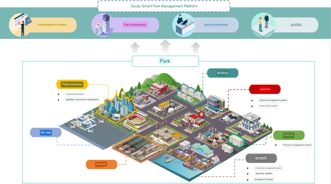
Guotu Smart Park Management Platform
02. Linked sensing and intelligence
Most parks cover large areas, have intensive personnel access, and have many public areas. Traditional security work is inefficient and increasingly difficult to cope with the various needs of many enterprises. Park management methods are in urgent need of intelligent upgrades.
The platform links the location and information of various smart devices in the park, marks the location and operating parameters of various sensing devices on the map in real-time, and quickly senses the status of the park. The sensed data includes park infrastructure conditions, underground pipe network status, access control checkpoints, personnel trajectories, cameras, and other key monitoring data. Intelligent sensing provides more valuable data information for smart campus data collision and top-level business applications.
By building a BIM model and integrating 2D and 3D basic geographical data, business topics, and intelligent sensing data, the platform forms a park data center with a "unified framework, consistent logic, data classification, and interconnection", and builds a full-space park base with unified standards to provide various services including 2D and 3D spatial analysis operators and capabilities to build a digital twin park, providing resources and capability support for park construction and management-related applications.
Deeply integrating BIM and IoT perception, the platform can monitor the operational safety of the pipe gallery space and internal pipelines and the status of ancillary facilities in real-time. It can respond to emergencies in a timely manner, such as sudden changes in pressure and temperature, automatic alarm messages, and support remote activation or turnoff of emergency equipment.
For infrastructure such as trash cans, garbage rooms, street lights, manhole covers, and fire-fighting equipment in the park, the platform associates the 2D information of the infrastructure with the 3D model and can be connected to the facility management system of the park to obtain the operating status and operation status of the facilities. rate, failure rate, and other information. The 2D and 3D linkage display provides a view of the real-time status of the infrastructure, solving problems such as high operation and maintenance costs, poor service experience, and difficult operation and maintenance in traditional campuses.
In order to visually present and monitor the three major modules of important hazard sources, pollution sources, and key protection targets in the park, the platform can access the park gas monitoring data and display monitoring data of the hazardous gas perimeter of key enterprises and the overall gas perimeter of the park. When the monitoring data reaches a certain critical value, an early warning function is activated to realize multiple gas monitoring and early warning and perimeter safety monitoring and early warning of key areas.
In the video surveillance section, the platform can visually present the location and distribution of cameras, realizing full-service video surveillance functions, including list synchronization of accessed videos, real-time preview, recording /playback, screenshots, status display, etc.; supports GPS terminals Scan the map to automatically turn on and off surrounding cameras; adjust the map position. When the map is in long view (zoom out), each district's overall camera data statistics are displayed. When the map is in close view (enlarge the map), you can view specific video surveillance point location information and can open the camera screen.
Combining video and 3D scene fusion technology, the platform projects the video streams of surveillance equipment in the park's outdoor and key indoor scenes into the 3D scene, achieving full-time-space stereoscopic fusion of video data and 3D scene data, changing the traditional mode that maps applications can only display statically to achieve real-time global control of the overall situation in the monitoring area and better support park security, emergency, and normal management.
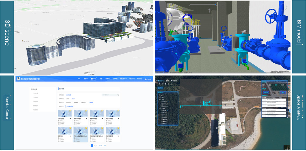
BIM refined management
03. Quick handling of hidden dangers
Based on the deep integration of park BIM model construction and IoT perception, the command and rescue business are closely connected to realize the visualization of the entire command and rescue business process in the emergency response mode, and the event task processing nodes are presented in a timeline manner to quickly link command, and coordinate the rescue. The disposal system is based on the incident handling process and time tasks, and mainly includes modules such as "incident reporting", "danger analysis", "emergency plan" and "on-site disposal".
The platform has built an emergency drill management system to realize normalized virtual drills and automated process assessments of typical accident scenarios: 1. Supports flexible editing and implementation of contingency plans and drill scripts; 2. Supports tracking, management, and evaluation of the entire drill process, facilitating sandbox style emergency drills; 3. The plan can be visually presented based on the event's impact and relevant plan documents, and various plans can be formed during the drill; 4. When an event occurs, the event-related plans can be associated and presented on the map, such as the plan type, event impact, plan handling process, etc.
The emergency command platform can display early warning information, event levels, event location, security personnel location, fire protection facility location, and emergency plans, and supports automatic alarm to public security and fire protection, synchronizing on-site alarm conditions and monitoring, making it easier for managers to understand the progress of the situation, which can provide intelligent decision-making support for park security management, security prevention, and public security incident control.
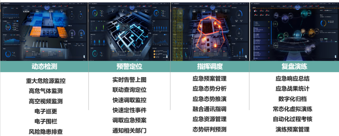
Incident response and emergency plan
04. Efficient park operations
Through big data technology, the park's daily investment operations and operations of enterprises in the park are integrated, and the platform establishes the park's big data geographical grid operation analysis. The platform standardizes, mines, and analyzes park resources, economy, land, security, and other data. Park managers can understand the operating status of the park at any time and fully control the park's operating situation. Once an emergency occurs, cross-department, cross-region, and cross-system collaboration can be achieved, resources can be uniformly dispatched, and responses can be quickly responded to, making the park data truly come alive and usable.
Using big data charts of operational status, the platform manages the usage of geographical information service resources in the park and the access status of various smart devices graphically, conducts statistical analysis on the reliability of signal sources of various equipment in the park, and provides efficient, comprehensive and complete one-stop big data comprehensive operation service, reflecting the park operation status in the portal or operation analysis module.
In the topic of land assets, the platform analyzes and evaluates real estate assets such as parkland, factories, and buildings, understands the assets of the park, and analyzes land use efficiency so as to guide park land optimization and new district industrial land planning.
Based on the economic benefits and tax information of the park's enterprises and production units, the park's efficient industries and high-contribution economic models are analyzed to facilitate the park's decision-making for the sustainable development of outstanding industries and production expansion.
Efficient energy management in the park is an important support for park operations and services. The platform manages water, electricity, gas, and other energy needs, and counts the usage, peak and valley values, general patterns, abnormal usage, etc. of various energy sources in various areas of the park buildings. The data is analyzed by region and category within the system, providing managers with management and optimization information on the efficient and green use of energy in the park, reducing energy consumption, saving operating costs, and thereby reducing the comprehensive operation costs of the park.
The platform forms a big data honeycomb map of the park's safety production based on the park's production safety and accident situation over the years. It analyzes the existing safety hazards and safety gaps in the park and links them with the emergency plan. At the same time, high-risk operation areas are marked in red on the map to prevent and control major safety hazards.
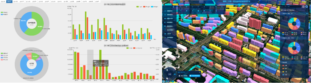
Topic on the economic and tax situation of the park


