Urban bus lanes are independent right-of-way lanes specially set up for buses. They are the bottom-line measures to ensure the smoothness of inner city roads and relieve travel pressure during peak hours. Geo-fencing is a technology based on mobile location services. It circles a virtual geographical area in the physical road. When the target enters or leaves this area, the system can automatically notify and alert. Through SuperMap iDesktopX, we build a real-time alarm system for geographic fences based on AR maps and AI. This system has four characteristics: global monitoring, geofence analysis, AI target recognition statistics, and real-time camera adjustment.
Global Monitoring
The system can access the video of road monitoring cameras in the whole area, switch arbitrarily to focus on the real-time video of the road, check the traffic flow, driving order and other information on the road, and at the same time can access the video screen of networked devices such as drones and mobile phones to achieve high and low stereo monitoring effect. According to this, the key areas can be monitored globally, and the roads, buildings, markers, etc. of the entire monitoring area can be viewed from the monitoring screen. If an emergency is found, it can be immediately switched to the nearest camera video of the emergency for quick viewing, achieving the diversified monitoring of traffic data.
Geofence Analysis
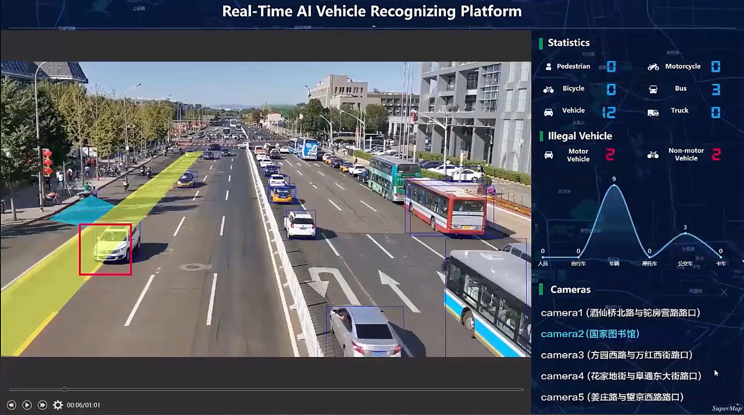
The road monitoring video stream data connected to the system can be superimposed and displayed with the existing geofence data, or the geofence data can be directly drawn in the video, and the video stream data can be analyzed based on the geo-fence data. After obtaining the actual location of the vehicle, the system conducts a geographic query with the fence of the bus lane, detects the detailed information of vehicles illegally entering the bus lane and non-motorized vehicles in real time, counts the types and quantities of illegal vehicles, records relevant violation information and sends an alarm.
AI Target Recognition Statistics
The system can automatically detect the type of target in the video, and count its number in real time, which is convenient for understanding the traffic flow of motor vehicles and non-motor vehicles on the road, as well as traffic congestion. For road sections with large traffic flow and traffic congestion, traffic police can be deployed for traffic relief. At the same time, the system can also conduct statistical analysis on vehicles illegally driving in the bus lane at different times, so that road managers can understand the distribution of illegal vehicles and better manage road traffic.
Camera Real-time Adjustment
When the shooting angle and area of a surveillance camera change, parameters such as video azimuth and pitch angle can be adjusted, the actual range of video shooting can be adjusted in real time, and the geofence data coordinates can be intelligently converted to avoid the mismatch between the video and the geofence data coordinates, requiring a manual conversion that would redraw the geofence.


