
1. Significance and necessity
To scientifically and reasonably measure and monitor forestry carbon sinks and their dynamic changes is an urgent need to address global climate change. On the basis of making full use of the existing forestry carbon sink source measurement and monitoring theories, technologies and methods, in order to meet the needs of the current society to cope with climate change forestry carbon source/sink measurement and monitoring, GTMAP (part of SuperMap) has studied the forestry carbon sink measurement and monitoring technology methods.
2. Monitoring objects
According to the IPCC (Intergovernmental Panel on Climate Change) definition of carbon pools in terrestrial ecosystems, monitoring objects mainly include five carbon pools of aboveground biomass, underground biomass, dead wood, litter, and soil organic matter, as well as greenhouse gas sources related to land use change and forestry activities/ exchange rate changes.
The work includes the acquisition of existing forestry survey data, sampling survey, determination of biomass survey factors, selection and fitting of relevant measurement equations, estimation of carbon stock and its changes, uncertainty analysis, and submission of results.
3. Technical process
We make full use of existing data sources such as forest resource surveys and wetland surveys to carry out carbon sink measurement and monitoring. Also, assisting ground remote sensing large-scale permanent plots surveys obtains land use types and change information within a certain range, combined with forest vegetation biomass measurement and land type change monitoring, to enable the measurement and monitoring of carbon storage changes caused by land use, land use change and forestry (LULUCF) within a certain monitoring period.
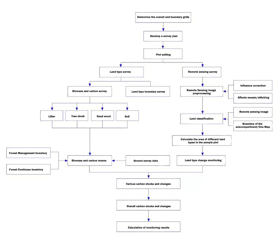
4. Technical methods
Carbon sink measurement and monitoring survey methods
Use the forest management inventory data and other relevant data sources to divide the overall boundary of the project area;
Use typical sampling, systematic sampling, or stratified sampling to sample plots within the scope;
Based on the completed sampling design map, use GPS And the compass to assist in the positioning of the sample plot and the setting of the sample plot, and carry out the survey of the sample plot. The survey objects include aboveground biomass, underground biomass, litter biomass, dead wood biomass and soil organic carbon;
Investigate and record the carbon pools in the sample plot according to the carbon pool field survey form and carbon pool survey method.
Carbon sink measurement and monitoring estimation method
Forestry carbon sink measuring objects include forests, wetlands, desertification, sandy land and parts outside forests.
Forests include arbor layer carbon stocks, shrub layer, herbaceous layer carbon stocks, belowground biomass, dead wood biomass, litter biomass, and soil organic carbon. The continuous/average biomass expansion factor method, the parameter equation estimation of the aboveground arbor layer relationship, the correlation between aboveground and underground, and the conversion of regional type parameters are used to estimate.
Wetlands include aboveground biomass, belowground biomass and soil organic carbon. It is estimated by establishing remote sensing models of the aboveground biomass of wetlands, summarizing the area of various types of wetlands, and summarizing various types of underground biomass.
Desertification and sandy land include aboveground biomass, belowground biomass and soil organic carbon. It is estimated by establishing a biomass remote sensing model and summarizing various types of biomass.
The outer part of the forest includes open forest, shrub forest, surrounding trees and scattered trees. The biomass of open forest is estimated by biomass expansion factor (BEF), and other carbon stock measurement methods are the same as those of forest.
5. Summary
Carrying out LULUCF carbon sink measurement and monitoring work to get the changes in carbon sinks caused by land use, land use change and forestry activities will provide powerful resources for forestry to cope with climate change and participate in carbon trading in the future.
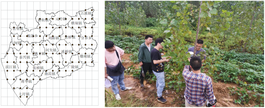
GTMAP undertook the pilot survey of vegetation carbon sink status in provincial forest parks in Lianyungang City. The carbon storage level of dominant tree species has been estimated, achieving a high performance, which provides valuable practical experience for in-depth research on carbon sink measurement and monitoring technology.


