SuperMap iServer is a server GIS software development platform that is distributed and extensible, which is based on high-performance cross platform GIS kernel. It provides full-featured GIS service publishing, management and aggregation functions, and provides multi-level expansion and development.
It provides powerful web services for geospatial big data, GeoAI and 3D to support massive vector/raster data "slice-free" publishing.
It deeply integrates microservice and docker layout, provides a variety of SDKs to build cloud native GIS system with micro service architecture.
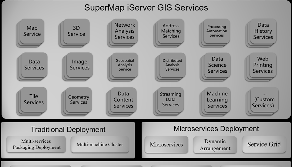
SuperMap iServer Service System Architecture
Product features of SuperMap iServer 11i(2022)
Flexible deployment, elastic scaling, high availability
Supports classic deployment modes such as single machine multi-process and multi-machine cluster, with high performance and high availability.
Supports microservice architecture and docker deployment mode, convenient deployment, fine-grained scaling, and resource saving.
Provides full-featured GIS microservices such as maps, data, distributed analysis, 3D, machine learning, streaming data, etc.
All-round extensible GIS service publishing and aggregation
Provides 2D and 3D spatial data publishing, management, editing, analysis and processing.
Provides domain geospatial service extension mechanism, including service capability, interface, security, cluster, etc.
Supports aggregation SuperMap platform services, tripartite services, OGC services and online map services.
Supports rapid publish of large-scale image (raster) data, and supports STAC-API specifications.
Provides processing automation service, and supports more than 900 kinds of analysis tools including vector, grid, 3D, image, GeoAI and spatiotemporal big data.
Dynamic management of service instances with high performance
Supports GIS service delay initialization, and iServer starts in seconds in the case of 100,000 level stock service.
Supports the active destruction of free GIS service instances to effectively reduce the occupation of system resources.
Supports the control of the maximum number of online GIS service instances to improve the system availability.
Multi-level distributed storage, computing and processing
Supports node dynamic accessing, intelligent scaling and automatic synchronization between nodes.
Supports MPP distributed relational database, distributed NoSQL database and distributed file system.
Provides distributed geospatial analysis, distributed data processing, streaming data real time processing, etc.
Supports the publishing, querying, editing and historical tracing of blockchain spatial data.
Accessing, processing and efficient publishing of geospatial big data
Provides distributed analysis service, and supports distributed processing and geospatial analysis of vector and raster data.
Provides streaming data service, and supports real time accessing and distributed processing of streaming data with 100 thousands/sec level.
3D data publishing, editing and analysis
Provides data publishing of 3D point, line, polygon, body, field, as well as oblique photogrammetry model, BIM and point cloud.
Provides online editing capability of 3D data to edit attribute and geospatial information.
Provides geospatial computing of 3D intersection, union and difference, and measurement and calculation of volume and surface area.
Provides 3D geospatial analysis of sunshine, skyline, visualization, 3D buffer, etc.
GeoAI supports the whole process
Provides machine learning services, and supports GeoAI analysis operator of target detection, ground object classification, object extraction, binary classification, decision tree regression, etc.
Provides work flow of covering sample production, model training, model evaluation, model reasoning, etc., and supports online interactive geospatial data scientific exploration based on Notebook.
Web map printing
Supports GeoPDF which is printed as A0/A1 map.
Supports secondary editing of geospatial/text information in printing results.
Provides extensible layout template for transportation, land, etc.


