Recently, SuperMap released the "Indoor GIS Integrated Solution". For the indoor GIS applications, SuperMap iMobile provides integrated solutions for indoor maps, indoor positioning, indoor search, indoor navigation, and indoor video maps.
The new 3D indoor navigation
Based on indoor 3D scenes, the 3D indoor navigation is more intuitive and identifiable than traditional 2D indoor navigation. The application covers large indoor places such as shopping malls, hospitals, office buildings, government halls, convention centers, libraries, airports, railway stations, etc. The functions are listed as the followings:
Indoor 2D map displaying and operations
Indoor POI search and details viewing
Indoor Positioning
Indoor cross-floor path analysis and navigation
Indoor voice navigation
Taking the railway station as an example, based on the indoor map of the railway station, the current ticket inspection information, train boarding information, train delay information, etc. can be pushed in real time.
The indoor and outdoor integrated navigation
The indoor navigation solves the "last mile" problem of outdoor maps, but in real applications, outdoor navigation and indoor navigation are often not coherent for various reasons.
SuperMap iMobile truly realizes the indoor and outdoor integrated navigation without manual operation, no matter from outdoor to indoor, or indoor to outdoor.
The functions of SuperMap iMobile indoor and outdoor integrated navigation:
The integrated indoor and outdoor map
The indoor and outdoor map integrated displaying switches indoor and outdoor maps automatically according to the current position and scale, and supports gesture operation.
The indoor and outdoor integrated POI search
It supports comprehensive search for data in indoor and outdoor data sources. For instance, when searching ATM, the search results will include indoor ATM and outdoor ATM.
The automatic switching between indoor and outdoor positioning
The outdoor positioning adopts the GPS method, while it cannot work in indoor. It can automatically switch to the visual inertia mileage positioning to indoor positioning.
The indoor and outdoor integrated path planning
When the start and end points of the navigation are separately located indoors and outdoors, the path of indoor start point (end point) to the gate and the path of outdoor end point (start point) to the gate are respectively planned in the path planning process. Then, the two paths can be connected as an integrated indoor and outdoor navigation path and displayed on the map in the same style.
The indoor and outdoor integrated navigation
According to the results of the indoor and outdoor integrated path planning and the position information obtained from the indoor and outdoor positioning, the indoor and outdoor integrated navigation and voice navigation can be realized.
The introduction of SuperMap indoor AR technology
SuperMap iMobile introduces AR technology into indoor GIS. It combines the indoor real scenes with indoor maps to bring a more immersive indoor GIS experience.
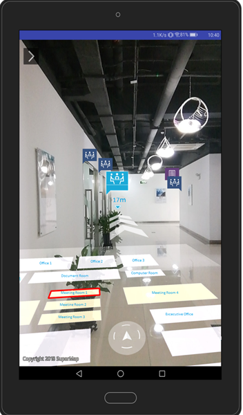
1) The AR indoor tracks collection and navigation
The AR can obtain the trajectory information of the indoor travel in real time through the visual inertial mileage positioning technology. It is convenient to check the the working range and area checked at any time after work or supervise the work. In addition, the collected trajectory can also become the route of indoor navigation through editing.
The AR indoor navigation combines AR technology with indoor navigation function, that users can see the panoramic route and the end position through the mobile phone camera. During the navigation process, the user does not have to repeatedly view the route information, but only needs to combine the voice, indoor real-scenes, then follow the arrow to find the direction and reach the destination.
2) The AR indoor object recognition and projection
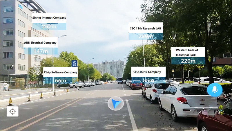
The indoor AR combines technologies of image recognition, real-time sensing, SLAM, GPS and others to achieve automatic matching of the relationship between sensor position, orientation, POI and other elements, and the 1:1 fusion of the real world and the virtual world. By placing virtual geometric images information and attribute information on the real scene display of the camera, and based on the real-time content of the real-time sensor, the virtual information can be updated through the human-computer interaction method of the touch screen gesture. Thereby, it can realize the rapid recognition of the object position and display more detailed real object space information.
In addition, SuperMap iMobile indoor AR also provides projection functions based on location, orientation, POI, etc. The projected content includes images, text, maps, videos, and so on. For instance, in a shopping mall, when the user points the camera toward a certain area, the 3D advertisement information of the area may be popped up, which may be in the form of text, picture or video.


