
Geospatial Agents, short for Geospatial AI Agents, are capable of understanding human intentions, autonomously planning and decomposing tasks, and automatically invoking geographic information software tools to achieve goals. Geospatial Agents developed for vertical industries such as natural resources, water management, and enterprise digitalization can address many critical business challenges in these sectors.
SuperMap has launched the Geospatial AI Agents series to unveil the technology behind Geospatial Agents and explore their application scenarios, solutions, and value across various industries.
This first article examines three types of Geospatial AI Agents built into SuperMap 2025, analyzing how Geospatial Agent technology is reshaping GIS software interaction models.
Current State Analysis: How Are the Three Types of Geospatial Agents Used?
A complete Geospatial Agent application consists of three layers: the Application Layer, the Geospatial Agent Layer, and the Geographic Information Software Tool Layer. The Geospatial Agent Layer relies on large language models (LLMs) and incorporates three types of Geospatial Agents based on their action capabilities and autonomy levels to meet diverse application needs.
The first type is the Knowledge Agent, representing the primary application stage. Trained on massive text data, it possesses language understanding and generation abilities to answer related questions. It also utilizes RAG tools and professional knowledge bases to reduce LLM hallucinations, avoiding "confidently stating inaccurate information" and improving professionalism. Although its capabilities are limited and it does not directly execute tasks, it has broad applicability and will remain relevant in the long term.
The second type is the Workflow Agent, representing the intermediate application stage. Unlike Knowledge Agents, it integrates human-designed workflows for fixed-scenario tasks, effectively reducing the complexity of LLM reasoning. It excels in task execution success rates and practical applications, serving as a transition from primary to advanced Geospatial Agent applications.
The third type is the Autonomous Agent, representing the advanced application stage. Regarded as the ultimate ideal form of Geospatial Agents, it offers higher autonomy. After a user issues a command, the system autonomously reasons and plans the task execution method, executing one step before replanning, generating the next task, and proceeding further. This iterative process continues until the task is completed. Currently, the task execution success rate of Autonomous Planning Agents is relatively low, primarily due to limitations in LLM reasoning and tool invocation. However, with rapid technological iterations, it is expected to become the most flexible and intelligent form of Geospatial Agents once fully matured.
Application Scenarios: How Are GIS Application Paradigms Innovated and Reshaped?
In the past, GIS applications required users to be both proficient in business knowledge and skilled in software operation. Typically, a manager and an engineer had to collaborate and communicate repeatedly to complete a task, which was time-consuming.
Geospatial Agent technology enables a new application paradigm for GIS software: natural interaction, autonomous thinking, and automatic execution. Users only need to express their requirements without in-depth knowledge of software operations, and the system can automatically execute tasks.
Below are some specific scenarios:
If a user wants to know how to build a large-scale visualization platform for a city, they can consult the AI online help feature of SuperMap iPortal. It not only recommends the corresponding product but also introduces its functions and advantages, providing valuable references for the user.
For data conversion and processing tasks, users can import 3D model files and 2D data into SuperMap TransformX, then set up the processing workflow: first, perform coordinate projection transformation; second, associate and attach attributes from the 2D data to the 3D model; third, conduct Geospatial alignment. After confirming the parameters, execute the process to generate a Geospatially aligned 3D model with attributes, achieving integrated graphic and attribute processing of multi-source heterogeneous data.

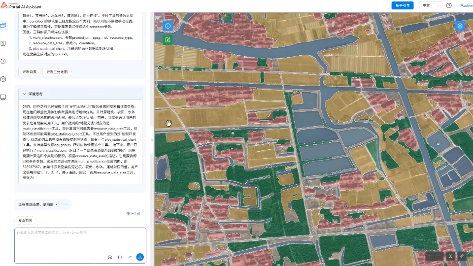
If a user wants to count the area of four types of features using rural land imagery data, they simply need to input the command. The system will autonomously engage in iterative thinking, plan the task flow, invoke interpretation tools to identify the features, use area calculation tools to complete the area measurement, and finally employ chart tools to create a ring chart and summarize the results. This entire process demonstrates autonomous thinking and decision-making capabilities.
Application Outlook: How Can Geospatial Agents Benefit the Industry?
Beyond reshaping GIS software interaction paradigms, Geospatial Agents can also address specific industry problems, which involves the development of agent service platforms or the customization of industry-specific agents.
SuperMap's Geospatial Agent service platform—SuperMap AgentX Server—empowers users to highly customize industry-specific agent solutions. It is compatible with large language models such as the Qwen series and DeepSeek series, and encapsulates SuperMap GIS and remote sensing capabilities into standard MCP service interfaces.
Additionally, it can extend industry tools based on the MCP protocol, complementing and enhancing the platform's native capabilities. In terms of tool completeness, it covers database tools, iServer tools, and iPortal tools, with ongoing improvements.

Furthermore, as domain-specific agents, Geospatial Agents have the advantage of cross-industry applicability, supporting the development of industry vertical agents for sectors such as natural resources, water management, construction, transportation, and cultural tourism.
What are the application scenarios for these industry agents? What industry pain points will they address? Stay tuned for follow-up articles in this series!